![]()
![]()
![]()
![]()
![]()
![]()
![]()
![]()
![]()
![]()
![]()
![]()
|
|
|
(p.139) Chapter 6 Reorganizing the Cities
Community responses to boom and adversity were reflected in the changing maps of individual cities. Booms were accompanied by explosive expansion and drastic geographical reorganization. In the auto era, urban land and floor space grew two or three times as fast as population. The effects of simple population growth were multiplied and complicated by increased travel, exchange, and material consumption. In the country as a whole, while the number of households tripled, trade and service employment grew sevenfold, and floor space per person more than doubled. The avalanche of personal vehicles, and the space needed to accommodate them, soon became obvious and gradually became legendary. But, aside from personal vehicles, the sheer physical volume of goods stored and used by an average household increased at least ten fold. Per-capita use of outdoor urban space for schoolgrounds, playgrounds, and residential lots rose in similar proportions. Meanwhile, the effects of obsolescence and decline were more extensive and more visible than they had ever been before. The railroad era had brought a vast increase in economic activity and wealth and, consequently, in the amount of construction. By the 1970s, railroad-era structures still accounted for more than one-fourth of the buildings standing in the nation and in the Upper Midwest. A half-century of auto-era changes in technology and geography had hastened the obsolescence of most of those structures. A high proportion of them were poorly maintained, worn-out, or even abandoned. Never before had a generation of Americans found itself living amid so many buildings and other structures which logically called for demolition, better maintenance, replacement, or rehabilitation. Demolition was usually nobody's responsibility. Maintenance required more money than the occupants of most old or obsolescent buildings could afford to spend. Replacement structures were usually built in more accessible or attractive locations. Rehabilitation depended on a strong, persistent demand for an old location. All of those problems were present in every settlement, and they were isolated in stark relief in areas of population decline.66
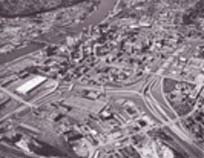
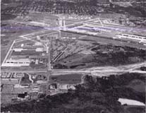
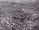
Growth Centers in the Prairies and the Plains Maps
of the change in five cities from 1920 through the 1970s illustrate the auto-era's reshaping
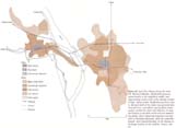
of growth centers outside the Twin Cities. Fairmont, Minnesota, was a strong-growth,
medium-size shopping and service center in the Corn Belt (Figure 45). Fargo-Moorhead,
Sioux Falls, Bismarck-Mandan, and Billings were leaders among the places that
emerged as new census metropolitan areas (Figure 46-49). Their populations grew from
three- to sevenfold during the half-century,
and their subdivided, urbanized areas grew at more than twice that rate.
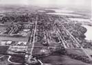
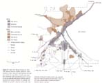
Fairmont, Minnesota, and its chain of lakes contrast with their Corn Belt suroundings, about 1980. The lakeside site is typical of many small towns and cities in the eastern half of the Upper Midwest. Pioneer settlers built at the present downtown location (center). In the 1880s, the railroads ran east to west at the north edge of downtown. A century of residential growth expanded away from the tracks and parallel to the lake shores. Photo, Fairmont Photo Press, Inc., Fairmont, MN.
(p. 141)
(p. 142)
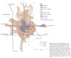
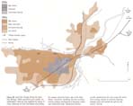
Figure 46. Land Use Change during the Auto Era: Fargo-Moorhead. Residential growth expanded away from the railway corridors, north and south from the central business district in Fargo, south in Moorhead, with high-value areas mostly following the narrow belt of natural woodland and miniscule local relief along the Fargo side of the Red River. Exponential growth of the city's already large farm supply and wholesale business resulted in explosive development on the outskirts, especially along the western freeway bypass. Source: note 66.
Figure 47. Land Use Change during the Auto Era: Sioux Falls. Residential growth expanded mainly in the established southwest middle- and upper-income sector, later to previously remote areas opened by freeways. Rail-oriented industrial-commercial areas exploded from the old core near the falls to the edges of the city. Source: note 66.
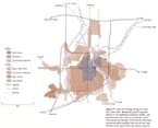
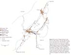
Figure 48. Land Use Change during the Auto Era: Bismarck-Mandan. Residential expansion spread mainly in the established middle- and upper-income sectors north of the railroad corridor to high, rolling prairie. Residential growth on lower, flat land south of the tracks was generally later, somewhat less, and aided in part by flood control projects on both the Heart and Missouri. In large part because of the flood control and one landown-• ing family, major commercial expansion was kept close to downtown Bismarck, while the remainder focused, more characteristically, on the freeway interchange location on the outskirts. Source: note 66.
Figure 49. Land Use Change during the Auto Era: Billings. While population grew sixfold, the subdivided or built-up area expanded by nearly 11 times, following the level benchlands and probing the canyons along the broken edge of the High Plains. Downtown rebuilding has been accompanied by outlying development of shopping centers and commercial strips. Warehouse-industry growth exploded from the area around the downtown railway stations to extensive highway-trackage areas well outside the rail-era city. Source: note 66.
City
limits were also enlarged to accommodate industrial expansion along the railway lines
leading into and out of the city. Those developments were often explosive in scale because
of the land needs of modern one-story factory and warehouse buildings, trucking, parking,
and sometimes even landscaping; and they usually pushed in directions away from
high-value residential land. The results are evident in the developments east from the business
center of Fairmont, in the remarkable lengthening
and widening of the rail-industry strips
along the historic Northern Pacific main line through Fargo-Moorhead,
Bismarck-Mandan, and Billings, and in the
extensive flatland development northwest of the old rail-industry
core of Sioux Falls.
Further
letting-out of corporate limits and dramatic reshaping resulted from freeway and highway
building. Most of the major highways bypassed the rail-oriented, older, congested
city. That avoided an immediate, obvious disruption of the existing patterns of land use
and circulation, and it held down right-of-way acquisition costs for the highway
departments.
But it gradually became obvious that avoiding long-term disruption of the old
city was
impossible. The new bypasses became the major force in the location of
industrial expansion,
airport development and related hotel construction,
and major shopping malls. Nearly every
mall was located at an interchange
in the direction of major high-value residential growth. Thus it could easily
penetrate the most lucrative market in the older
city,
capture the trade from the largest and most affluent areas of auto-era expansion, and
invade
the trade areas of neighboring smaller towns. In some cases, the new highways also spurred
development of attractive residential land that had been avoided throughout the railroad
era because it was on the wrong side of the tracks or the wrong side of a river barrier.
Now new large-scale subdivisions ignored previous constraints, leaped over old
outskirts or slums, and capitalized access to new, highway-oriented
job locations. The results of those forces
are evident in the development patterns
of all five cities.
Enlarging
and reshaping those growing cities was
clearly a complex community task. The
larger cities added an average of 100 to 200 acres
of new land per year. Even Fairmont added
an average of perhaps 40 acres per year. Land
was subdivided, permits issued, buildings erected, streets and
utilities extended. The community had to
orchestrate a continuing procession
of development decisions, actions, and reactions—both public and private, local
and regional. Such a process had characterized
city building from the beginning; but the
rate, scale, and number of actors increased sharply in the auto era. In the midst of each booming city there was also decline. The cities had been turned insideout. The original central areas became museums of the rail and streetcar era: derelict railway stations, wall-to-wall multistory buildings with narrow frontages, little parking space —all separated from the freeways by many congested blocks. As the threat of deterioration became clear, leaders in the cities began in the 1950s and 1960s to try to define the problems and the community actions that looked practical. Fargo and Moorhead were among the country's first cities in their size classes to enter the long, trial-and-error struggle toward central area renewal. Organized city and private actions came a little later in Sioux Falls, Bismarck, and Billings. Large outlays of private and government funds, both local and federal, helped to stimulate the activity. The results were extensive clearance of marginal business blocks and fringe residential areas; experiments with assistance in relocating people and small businesses; rehabilitation; street improvements; and construction of public buildings, high-rise apartments, hotels, office buildings, and new retail developments. The task is still far from complete. The reasons for delay are familiar: abundant, good-quality new housing on the open land in the outer areas; difficult access to central areas from the freeways; railroad blight; difficulty in bringing together enough large institutions to generate a downtown office boom. The development process was controversial and educational. The need became clear for not only a long-term strategy but also a long-term community-wide commitment, a great deal of money, and two or three decades of time. On a smaller scale, Fairmont joined dozens of other cities in rehabilitating and redeveloping its original central area.
(p. 147)
Figure 50. Land Use Change during the Auto Era: the Copper Range. The map reflects the loss of more than half of the 1920 population, together with the abandonment of mines on the upland ridges and smelters on the waterfront. Abandoned railroad mileage exceeds the arterial highway mileage. The settlement pattern has evolved from a constellation of mining, smelting, and port locations, each with nearby workers' neighborhoods, to a system of scattered residential clusters of commuters, pensioners, and local service employees, centered on Houghton and Hancock. Source: note 66.
(p. 148) Transformation of Lake Superior Cities Maps of the Copper Range complex and Duluth-Superior present a much different picture. Changes in the Copper Range reflected both the total loss of the original economic base and the partly counteracting gains from tourism and interregional income transfers by state and federal governments through Social Security, medical programs, education, and construction projects (Figure 50). From 1920 to 1980 total population of dozens of small mining locations plummeted from 53,000 to 23,000. In the mid-1980s, the remains of those compact, pre-auto villages were strung along today's highways and back roads and also along miles of abandoned railroad grades. Some nineteenth-century, frame miners' houses and tiny clumps of brick business buildings were still in use. But on many vacant lots only a few overgrown foundations and cellars remained. Some of the mine locations are marked today by one or two houses or a historical plaque. On the surrounding ridges and swales, the cutover landscape of stumps, brush, and saplings has given way to a revived forest that once more softens the horizons and hides the excavations and waste-rock dumps. While some of the remaining houses showed signs of dilapidation and austerity or poverty in the 1980s, the majority had been maintained and modernized with income from jobs in the principal range cities, logging, or tourist trade. The history and the cool Lake Superior climate attracted summer tourists from sultry cities to the south. Autumn leaves, hunting, and exceptionally deep snow for skiing drew visitors from the same markets in other seasons. Small flocks of former residents and their descendants, returning for village and township reunions, added to the summer tourist inflow. Scores of Copper Range expatriates gathered at places where only a handful live today, to recall or learn about old times. They came from California, Texas, the urban Midwest and Northeast, and the retirement colonies of Floria, as well as many other places in the United States and abroad. Perhaps the most striking monuments to the past mining booms were at Calumet, near the northern end of the Copper Range. Partly devoted to boutiques and exhibits in the early 1980s, the sprawling cavernous stone shops and offices of the once-mighty Calumet and Hecla Consolidated Mines brooded over several hundred partly subsided acres of derelict railway grades, foundations, waste-rock dumps, and rusting frames. Hundreds of miles of partly collapsed, water-filled tunnels honeycombed the underlying bedrock. Nearby, impressive blocks of monumental brick and stone buildings reminded curious visitors that the downtown once served a local market of 20,000 inhabitants. The frame homes that remained around the downtown in the 1980s housed scarcely 1,000. A monument on the library grounds recalled the philanthropy of Alexander Agassiz, the Bostonian who ran the Calumet and Hecla after the Civil War. In the 1870s, at about the time Minnesota naturalist and historian Warren Upham was naming glacial Lake Agassiz for Alexander's father, Louis, Alexander was donating civic improvements to his temporary hometown out here on the frontier. Local place-names such as Atlantic Mine, Boston, and the famous Quincy Mine reflect the early importance of Boston capital and initiative in the Copper Range. The resulting philanthropy came to rest more on the Harvard campus than in the Range. And most of the earnings —perhaps inevitably—moved into America's massive, fast-growing stream of investment capital through Eastern trusts.67 In contrast with most of the other places, the population of Houghton-Hancock was steady from 1920 to 1980, at about 12,000. Employment in retail trade held barely constant, while service-employment doubled. Service employment growth reflected in part the rising tourist trade, but other factors even more. There was diversification and expansion of the historic state college of mining technology and expansion of medical and social services by both federal and state governments. Especially important were services to the elderly, who made up a large part of the Copper Range population. Along the once-busy ship channel, extensive restoration in the 1980s was changing the face of Houghton's downtown.
(p. 149)
Figure 51. Land Use Change during the Auto Era: Duluth-Superior. Harbor, lakeshore, transportation routes, and open land dominate the vast area within the city limits. Growth areas have been relatively small and abandonment extensive in the pre-auto rail and heavy industry areas of Superior and western Duluth. In contrast, substantial new growth —based on service jobs —has sprawled among the stunted groves and tamarack bogs and captured spectacular panoramic views, on the rocky uplands above central and eastern Duluth. Source: note 66.
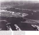
The Copper Range had a drastic change in urban structure from 1920 to 1980. It lost almost as much population as some of the large, fast-growing urban areas of the Upper Midwest gained. Census population data suggested a debacle. The visible ruins added to that impression. Yet, eventual depletion of the copper ores was always a certainty. Earnings from exploiting the deposits have been spread among a vast and varied array of developments worldwide. The people who lived on the Range in 1980, and those who returned for summer reunions, were both intellectually and materially much better off than the immigrant laborers and perhaps even their schoolteachers, ministers, doctors, and merchants in the rough-and-tumble settlement of the 1860s and 1870s. For thousands of families, the Keweenaw was a way station on geographically twisting, economically upward paths from scattered origins in Europe to equally scattered destinations in America. While they lived and toiled there, they contributed to the world's swelling stream of capital. We can only speculate or wonder what the situation would be if the people and capital had been less mobile. The Twin Ports of Duluth-Superior presented a more striking picture of maintenance and growth amid obsolescence and abandonment (Figure 51). Centerpiece of the urban area in 1980 was still the spacious harbor. A nineteenth-century whaleback freighter near the modern hotel and yacht basin on Superior's waterfront is only one small part of the harbor's living museum.
Some of the great, dredged promontories on the bay were vacant and overgrown, edged by rotting pilings, washed by the waters of quietly silting slips. Hundreds of acres of railway yards were used at a fraction of their capacity. Other hundreds of acres were virtually abandoned. Nearly 5,000 transportation jobs had disappeared between 1929 and 1980, as trucks took over a large share of the grain traffic and new railway equipment reduced turnaround time for grain, coal, and iron shippers. Near the head of the bay, the steel mill was cold and rusting away—as it did while hundreds of jobs disappeared during its last decade of operation. The neighboring cement plant was silent because it lost its source of raw material when the steel mill closed. Yet there was much activity at scattered locations along the sprawling harbor. Even in a depressed steel economy, millions of tons of taconite pellets moved through the ore docks in western Duluth and the southeastern outskirts of Superior. Tens of millions of bushels of grain moved through the elevators on Rice's Point and along the Superior waterfront, and a new terminal transshipped Montana coal to the lower Great Lakes. Duluth's post-World War II general cargo terminal on Rice's Point served dozens of freighters at the upper end of the Great Lakes-St. Lawrence Seaway. Widely scattered industrial plants, including a large, new papermill, enlarged on nineteenth-century traditions in wood- and metal-working. There was also much uncertainty. Changing steel requirements and foreign competition made iron pellet shipments more variable. The volume of grain shipments was also increasingly variable as more of the flow was directed to international markets, with resulting competition from Pacific and Gulf ports. The general cargo port was competing against the much larger market and more frequent sailings at Chicago. Post-World War II residential expansion in areas around the bay had been miniscule. Much of it had been in the vicinity of Morgan Park - once a planned company community, designed and built at the time the steel mill opened in 1910. Though the mill was defunct, the carefully designed residential area had kept its amenities and enhanced its status. In contrast with many port-rail-industry areas, maintenance, or even growth, was prevalent in other districts —notably central and eastern Duluth. Employment had grown on the campuses on the east side, in the services and light industries downtown, and fitfully around the airport during temporary periods of military expansion. On the downtown Duluth waterfront, some of the big, mul-tistoried buildings that housed the great hardware and grocery wholesalers at the turn of the century were subdivided, rehabilitated, and partly occupied by a new generation of light industry and offices. Impressive rehabilitation and redevelopment was gradually lifting the face of the railroad-era business district. Energy for those improvements came from generous federal construction grants as well as the downtown economic base. The central and eastern high-density residential area had expanded one-third since 1920. Additional low-density development had sprawled across another dozen square miles. The expansion resulted from replacement. Although the net total of metropolitan population growth was near zero, new housing in the central and eastern heights had continually replaced deteriorated housing in the old cores and industrial west end. Newer dwellings had replaced perhaps one-third of the units in use in 1920.
(p. 152)
With the help of generous federal and state funds, a network of modern highways and spectacular bridges was gradually stitching together the sprawling and varied metropolitan patchwork; and a long-enduring planning program kept nudging the pieces into place. The Twin Ports in 1980 presented an unusual and dramatic view of the powerful auto-era thrust of service growth, federal and state expenditures, industrial transformation, and international interdependence. Because the metropolitan area was not buried in layers of recent growth, it offered an exceptionally clear exposure of the obsolescence and maintenance problems that have beset most cities in the auto era. The problems have not been unique to the Twin Ports, only more prominent because of the slow counteracting growth. Nor was the growth experience here unique among America's more than 300 metropolitan areas. In the years since 1920, only eight have experienced such chronic non-growth as Duluth-Superior. But 30 more have experienced little or no growth during three or four consecutive decades, and another 130 have had one or two decades of nongrowth. The historical geography of the northeastern United States and other areas around the North Atlantic is replete with cases of prolonged nongrowth of cities. The record suggests that the Twin Ports might feel an occasional resurgence, but it also suggests that their nongrowth experience could be shared by many other cities in the coming decades. The Duluth-Superior communities were indeed coping with obsolescence. But they were also running an urban laboratory experimenting with the future.68 The Regional Metropolis In all the transformation of the Upper Midwest in the auto-air-electronic age, the most dramatic and intense changes came in the regional metropolis. The changes incorporated both boom and obsolescence on massive scales. In the auto era, the Twin Cities area absorbed half the net out-migration from the rest of the Upper Midwest. It accounted for more than half of the employment and population growth in the entire region. Its daily commuting area in 1980 covered more than 10,000 square miles. In many ways the metropolis had become a region in itself.69
In a little more than half a century, the urbanized area - including the scattered subdivisions on the outskirts —grew from 160 square miles to 880 (Figures 52-53). Population of the urbanized area grew from 670,000 to 2 million. The total outlay for construction of all kinds was more than $20 billion at the prices current at the times of development. In constant 1980 dollars, the investment was probably over 40 billion. If it were to be replaced at 1985 standards for roads as well as residential, commercial, and public structures, the outlay would surely exceed $60 billion; and those figures do not include the cost of interest on borrowed money. The building took place along 3,000 miles of new streets and roads on about 500,000 parcels of land into which the 1920 farms had been subdivided. Thus the billions were invested as a result of hundreds of thousands of decisions of families, corporations, and governments. It was a kind of community project; almost everyone was involved. Together they created an outer city, surrounding the older inner city.
Auto-era expansion has taken place in three stages: the building boom of the 1920s and the following hiatus of the Great Depression and World War II; the post-World War II building boom (and baby boom) from 1945 until about 1960; and the subsequent period of maturation of the outer city. THE 1920s BUILDING BOOM
This boom was the first in American history to be affected by automobiles, and even then their potential impact was still in some doubt for many investors. In the Twin Cities, most auto-era development before World War II followed the directions of earlier streetcar expansion. In fact, much of it filled in vast areas in the outer parts of Minneapolis and St. Paul that had been subdivided in the previous boom and not yet built upon. But there were suggestions of other changes that would come in the future on a massive scale. Abundant credit encouraged construction of new dwelling units faster than new households were formed. As a result, there was a high rate of replacement building, and the surplus new units could replace old ones which could then be discarded. While new areas boomed, it was possible to abandon some of the least desirable, oldest housing. The abandonment showed up in the city residential cores. It reflected the accelerated obsolescence of many older houses, with primitive wiring and piping, on small, crowded lots. Central heating and garages had become standard; and burgeoning demand for major appliances had created the need for modern plumbing and wiring. With the 1920s skyscrapers, the downtowns were building more upward than outward. The result was a widening "gray zone" of accelerated obsolescence and some abandonment in the older housing stock, surrounding the downtowns. Then the first large department stores to be located outside the downtowns opened their doors in connection with the giant Sears and Montgomery Ward mail-order houses in south Minneapolis and in the St. Paul Midway. Thus the forces of change had appeared, but they were slowed by the 1929 crash and the decade of the Great Depression that followed.
(p. 153)
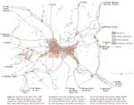
Figure 52. Land Use in the Twin Cities, 1920. The Upper Midwest metropolis was a compact streetcar city. Most of its 670 thousand people lived within about 80 square miles focused on the job locations in the main railroad corridor from north Minneapolis to South St. Paul. The halo of low density settlement on the outskirts reflected the scant beginning of automobile commuting. Except for the streetcar and summer cottage suburbs around Minnetonka and White Bear lakes, the bountiful supply of shoreland and rolling glacial terrain was still used for farming. Source: note 66.
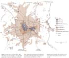
Figure 53. Land Use in the Twin Cities, 1980. The streetcar city was engulfed in more than 800 square miles of auto-era subdivision and development. Homes and work places for an additional 1.3 million people had spread over former farmland and along rural lakeshore of 1920. A 500-mile web of freeways had extended and reinforced the rail transportation network. Source: note 66.
THE POST-WORLD WAR II BOOM
Explosive growth erupted in 1946, following fifteen years dominated by depression and wartime austerity. Employment was growing rapidly. There was pent-up demand from the long period of under-building. The Congress insured liberal home-financing credit for veterans, who accounted for most males in the family-forming age group. And this time almost every household owned an automobile. To be sure, the automobiles could not get out of the city very far or very fast on the remarkably primitive highway system of that time. At the end of World War II, no more than three dozen narrow, mostly two-lane paved roads reached even 10 miles outside the Minneapo-lis-St. Paul city limits. As hundreds of feeder streets were graded for burgeoning subdivisions, congestion began to develop on the limited number of arterials. Nevertheless, it was a big improvement over walking from the end of the streetcar line in the 1920s. In 1920 only 250 square miles of land area lay within one hour of travel time, by a combination of trolley car and walking, from the nearest downtown. With auto travel, the one-hour area exploded to about 2,000 square miles. As a result, hundreds of previously inaccessible square miles had suddenly come into the urban real estate market. The consequence was relatively cheap land, larger lots, and lower density compared with earlier expansions — the sprawl of the 1950s.
In the frenetic effort to grade streets, run electric power lines, complete homes, and do basic landscaping, there was little time or money left over. First priority for the remaining funds went to building elementary schools as the baby-boom youngsters reached age six. Most of the remainder went to pave the streets and equip playgrounds. Residential growth advanced well ahead of employment. Suburban businesses consisted mainly of building-supply yards and convenience retail centers. Many of the centers were little more than enlarged hamlets from the recent agricultural past. Growth also ran far ahead of sewer and water extensions. At the peak, about 300,000 people in the first ring of suburbs were dependent on their own wells and septic tanks. When the baby boom ended about 1958, a sea of single-family homes had filled all the partly developed outskirts of the 1920s and pushed a few miles farther into the countryside. The main thrusts followed level land north and south from Minneapolis, into southwestern St. Paul, and surrounded a few old streetcar suburbs. Most builders stayed with flatland to hold down excavation costs, or near the edges of older municipalities for access to water systems. But most of the fast-growing suburban population was using inadequate roads and city streets to reach central-city jobs, doctors, shopping, and entertainment. Downtown crowding, sewer problems, highway needs, and school construction were demanding further attention. MATURATION AND CONTINUED GROWTH Meanwhile, new forces had been gathering through the mid-1950s and emerged dominant in the 1960s. An unprecedented rise in real income was affecting most households in the Twin Cities, as it was in the nation as a whole. The Exploding Metropolis had yielded to The Affluent Society as best-selling nonfiction. Suburbs had emerged as a major market, labor force, and tax base with large, urgent demands. Freeway plans were nearing completion, and construction of the network was under way in the late 1950s. With those plans in mind, Dayton's department store in Minneapolis built the world prototype enclosed suburban shopping mall, Southdale in Edina. General Mills and 3M began to create two of the nation's earliest suburban corporate office and research campuses. Freeway construction sparked much more highway improvement. As the new network gradually approached completion through the 1960s and 1970s, more and larger shopping malls, office parks, and industrial parks developed near the main interchanges. The belt freeways, girdling the metropolitan area, interconnected the new mass of homes, shopping areas, and job locations. The belt lines also joined the entire suburban ring with the major radial highways that led not only inward to the downtowns but also, more importantly, outward to the rest of the region. The outer city could now become a new focus for both the metropolitan area and the regional economy.70 Long-gestating community improvements soon accompanied the highway and business investments. Suburbs initiated large, new sewer and water systems. Suburban school districts consolidated and built mammoth new high schools. Suburban congregations moved from temporary quarters in grade schools, quonset huts, and taverns to monumental new churches. schools, quonset huts, and taverns to monumental new churches. The Airports Commission made its first round of massive improvements, and Wold-Chamberlain Field became Twin Cities International. The new suburban municipalities built civic centers, libraries, and fire stations to replace sagging, nineteenth-century, wooden rural town halls. Finally, city and county parks, private and public golf courses, and state junior college campuses occupied some of the remaining gaps in the development pattern.
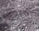
Central Minneapolis, viewed from east to west in 1983, was in transition. The falls of St. Anthony-constrained by dams and concrete aprons, bypassed by locks-and the historic bridging point at Nicollet Island lie upstream from the center of the picture. The transcontinental rail corridor was busy, but large old yards were being abandoned in response to changes in railroading and pressure for redevelopment. Once a child of the falls and rail lines, the downtown had become a focus in the freeway system and the locus of massive new construction and rehabilitation. The expanded University of Minnesota campus straddled the river between the downtown and the major concentration of grain elevators (foreground). Aerial photo by K. Bordner Consultants, Inc., Minneapolis, MN.
Also in transition was central St. Paul, viewed from northeast to southwest, 1985. Oversize parking ramps for automobiles from today's converging freeways occupied the riverside location (left center) of the former Union Depot train sheds-once the focus of the region's rail network. With the river dammed and dredged, and the entire frontage improved, the original landing below the Union Depot was an inconspicuous spot amid barge fleeting and pleasure craft operations. New towers rose among restored, old structures in the downtown core. Around the edges, extensive redevelopment and rehabilitation combined to change the face of "Lower-town" (lower center), the state capital area (right), and the hospital-public arena complex (above). Aerial photo by K. Bordner Consultants, Inc., Minneapolis, MN.
Amid these changes, support rose for coordinating the public improvement programs of the scores of local governments, state agencies, and special districts that made up the metropolitan area. Together they were using public revenue collected by local, state, and federal governments to build the basic skeleton of the outer city. The support grew out of both the frustrations of the frenetic boom years and the obvious, growing management problems now that the community was catching up with the backlog of major public construction. Thus the Minnesota legislature created the Metropolitan Planning Commission in 1957, then strengthened, broadened, and renamed it the Metropolitan Council in 1967. Within a short time, the council had to make influential decisions on eventually unsuccessful proposals to build a new super-airport on the Anoka Sand Plain and to build a new subway system focused on the central-city downtowns. Both projects would have made important shifts in the location of public capital investments within the metropolitan framework, whether or not they would have affected the overall pattern of growth. The council then produced its metropolitan development guide in 1970 and first defined the urban services line, to limit the rate and sprawl of the sewer and water network, in 1974.71 The housing market also changed in the 1960s. The array of choices became more diverse as the share of new housing construction in single-family units dropped from nearly 100 percent in 1955 to about 60 percent during the following decade. Apartments, then condominiums, made up the other 40 percent. Also, the replacement rate rose to an unprecedented level. That is, new houses continued to be built at a high rate, although the rate of new household formation declined. As a result, more people all the way down the housing chain could move up into new quarters more quickly, and old housing at the bottom of the chain could be abandoned at an unprecedented rate. Most of the new housing was built in the outer city, and virtually all the abandonment of older and dilapidated housing was in the inner city. THE
NEW OUTER CITY By 1980, a new outer metropolis indeed existed. It had been built to accommodate 1.7 million people, or more than half a million households, with automobiles. It included all the suburbs plus the post-1920 edges of the central cities. It spread across rolling land, around hundreds of lakes and ponds, among tens of thousands of acres of woodlands, with abundant parks and playgrounds. On its inner margin were the major parks which had been developed from farmland nearly a century earlier, and 50,000 acres of recently created regional parks and preserves lay in its outer margin. The new outer metropolis was bound together by the nation's highest per capita metropolitan freeway mileage and a highly developed grid of arterials. The outer city focused on eight major shopping malls and the vastly upgraded metropolitan airport. It also included several sprawling assemblages of offices, hotels, and industrial parks around the principal interchanges on the belt freeways.
Of the one million jobs in the metropolitan area in the early 1980s, more than half were located in the auto-era outer city. Metropolitan area retail sales rose from $1.3 billion in 1958 to $7.3 billion in 1977. But in the same period, the downtown shares of the total had fallen to 5 percent in Minneapolis and one percent in St. Paul, while the major shopping malls had captured 12 percent. Fifty-two percent of all sales were in the garish suburban commercial strips, where there had been virtually nothing in 1920. In addition to hundreds of new firms, nearly 300 industries from Minneapolis and nearly 50 from St. Paul had moved to more spacious quarters in suburban industrial parks between 1960 and 1977. In 1982, the auto-era ring contained 31 million, or well over half of the 58 million square feet of metropolitan area office space less than 15 years old. The downtowns were home to the office headquarters for most of the largest business firms with the greatest assets and also for the largest government offices. But the suburban ring, with generally lower development costs, housed more of the young fastest-growing firms and the greatest number overall.72 Impressive as the outer city had become, older parts here and there were already beginning to come unraveled. Some early post-World War II commercial strips were obsolete. Their locations had poor access to the freeways, vacancy was high, building maintenance was neglected, and parking spaces were broken and weedy. The giant sports stadium, opened in the late 1950s, replaced in 1982 by the downtown Minneapolis dome, was abandoned and awaiting eventual clearance andredevelopment. Schools built for the baby boom of the 1950s were redundant. (p. 159)
Twin Cities International Airport, 1983, grew from a grass field and small frame hangar on the site of a defunct auto-racing track of the 1920s to be one of the country's major hub airports. The complex occupies the flat peninsular plateau east of the Mississippi (upper right) and north of the Minnesota River (bottom). Historic Fort Snelling stood at the confluence, just east of the present airport. Several square miles of sprawling runways, ramps, terminals, and major airline headquarters made up the air-age version of the rail-era downtown depots, yards, and railroad company offices. The airport succeeded the rail terminals, the riverboat port, and the old fort as the fourth generation of regional transportation nodes. Office-industry-hotel developments (lower left) follow the freeway about seven miles west to the Edina interchange, shown in the following picture. Aerial photo by K. Bordner Consultants, Inc., Minneapolis, MN.
The nearly uninterrupted level plain south of downtown Minneapolis (upper right), which accommodated most streetcar-era growth, contrasts with the rolling, lake-studded moraine land, the scene of most auto-era expansion. Roughly the lower two-thirds of the area pictured in 1984 was built up since World War II. Western and southern legs of the first belt freeway around Minneapolis intersect in Edina and Bloomington, in the foreground. The high-rise concentration in downtown Minneapolis (top center) is eight miles to the northeast. Aerial photo by K. Bordner Consultants, Inc., Minneapolis, MN.
NEW ATTENTION TO THE INNER CITY In the center of the 800-square-mile suburban ring lay the 50-square-mile inner city, entirely within Minneapolis and St. Paul. To be sure, all the inner city was not literally pre-auto. Although all of it was subdivided and settled before the auto age, parts of it had been rebuilt at least once. The downtowns were the scene of frequent though fitful and partial replacement of old buildings by new ones almost from the beginning. There have been major redevelopments over the years in some of the central cities' outlying districts, notably the Honeywell headquarters complex, the hospital zones, the University of Minnesota campus, and the public clearance and housing projects.
But redevelopment had accounted for less than one-tenth of the inner-city area. From the 1920s through the 1960s most of the pre-auto city had been the scene of creeping obsolescence and abandonment. The obsolescence was coupled with deferred maintenance on many buildings and streets. Abandonment was coupled with deferred clearance or redevelopment. There was a general spreading of low income and low investment. The situation was the result of a stubborn syndrome of problems. Except for the federally financed interstate freeways, highway improvements did not penetrate the inner city "lump." Even the interstate freeway penetration was slow. Higher welfare and police costs accompanied the changes in population and land use, while costs also rose for even minimal care of aging improvements. Those expenses kept real estate taxes high. And before anything new could be built, costly demolition and removal had to take place. Consequently, in competition with the suburbs, inner-city land suffered from less accessibility, higher taxes, and higher land preparation costs for new development. In one way, the lump of older, obsolete structures was part of the pervasive American solid waste problem. Unlike cans and bottles, the buildings could not simply be tossed out of sight. But they could be left behind as the metropolis turned its back and faced outward. Yet, if you believed that the Twin Cities metropolis was here to stay, perhaps you had to believe that this relatively small area in the middle of it merited recycling. Beginning in the late 1950s, strong counterforces began to develop and converge on the inner-city malaise. They came from different sources, partly related, partly coincidental. Together their effects were truly impressive. With 90 percent federal financing, the interstate freeways penetrated the inner city in the 1970s. Costs had been high and delays lengthy because of the need for demolition, resettlement, and compensation for a wide range of unprecedented social, economic, and physical damages. But eventually the freeways restored metropolitan accessibility to the downtowns. The freeway plans, coupled with other federal aid opportunities, sparked comprehensive plans for redevelopment. The St. Paul Capitol Approach plan took on new life, and the Minneapolis Metro Center plan evolved rapidly. Basic hopes and themes reappeared from the proposals of a half-century earlier—monumental central-city cores, riverfront development and beautification. This time action quickly accompanied the planning.73 City government, large corporations with local control and inner-city headquarters, major hospital and medical centers, and neighborhood resident organizations soon joined in the effort. Major developers were attracted from other centers of investment capital in the United States and Canada. The city governments and specially created authorities funneled federal subsidies to target areas. Money went to realign and improve streets, build parking ramps, improve public buildings and parks, and subsidize new housing and home improvements as well as subsidize interest rates on bonds for new major construction. The cities borrowed heavily to buy land, clear it, prepare it for new development-and to make accompanying public improvements and embellishments. The private organizations, in turn, made heavy commitments to new construction. And the neighborhood organizations labored to keep a share of the public improvement funds flowing into residential areas and a share of the subsidies directed to family housing. Plainly, with the complexity of the script and the diversity of actors, a great deal of learning and negotiation was necessary to evolve the plans and translate them into action. The resulting boom has been peaking in the 1980s. Meanwhile, in the late 1970s the post-World War II baby-boom generation entered the housing market. That happened at a time of unprecedented national inflation. With building costs high and interest costs rising, the new generation could not do what their parents had done in the housing crisis of the late 1940s: go to the outer fringe and build a rambler. Instead, they turned inward. They bought into the vast, older housing stock in the transition zone between inner and outer city and set out to improve it. Thousands of households were soon burning the lights late at night, pouring "sweat equity" into older houses and yards, just as their parents had with new ones three decades earlier. While public outlays were important in bringing new life to those older neighborhoods, private outlays were far greater. Although most of the activity was the result of average young families renovating average old houses, some involved higher-income young families renovating fine old mansions and gentrifying historic, once-prestigious neighborhoods near the edges of the downtowns and in the lake districts. Thus the central cities' ring of deterioration was shrinking and even partly dissolving in the 1970s. A new wave of downtown improvement and gentrification was pressing against it from the inside, and a wave of house-painting, cabinet-installing, carpet-laying younger families pressed from the outside. As a result, abandonment came virtually to a halt, and there was more crowding of the lowest-income and the transient populations. (p. 162)
A historic preservation movement also converged on the inner city in the 1970s. If housing is an indicator, the average life expectancy of a building in the United States is about 80 to 100 years. The first large wave of construction of monumental buildings in the Twin Cities began with the rise of the Northwest Empire after completion of the northern transcontinental railroads. That was in the 1880s and 1890s. Eighty to 100 years later, Twin Citians faced for the first time the abandonment and destruction of hundreds of architectural monuments that commemorated important people and institutions in Upper Midwest history —office buildings, warehouses, churches, homes. Consequently, other forces coalesced on the stage. At first there were protests and rallies. Then buildings were surveyed and classified. City and federal tax subsidies were aimed at helping private investors restore high-priority, well located structures. The oldest, most durable, monumental, and well-situated structures were in or near the downtowns. For at least the first round of historic preservation, the major targets were in the inner city.74 As a result of these converging forces, the inner city in the 1980s was probably in the best physical condition in its history. Increasingly the downtowns were impressive collections of restored old facades, tastefully remodeled interiors, gleaming towers, fountains, designed open spaces. Forty- to 60-story towers dwarfed the rail-era skyscrapers of 12 to 18 floors. The buildings were monumental and their functions diverse: offices, hotels, shops, pedestrian malls, auditoriums, sports arenas, concert halls, theaters, housing, enclosed skyways. The Metropolitan Council estimated that resident population in and adjacent to the downtowns would grow by 25,000 in the 1980s and early 1990s. The boom had produced at least $2 to $3 billion in private and public investment in the inner city. A large share was downtown, but the flow to housing and public improvement in the neighborhoods was also large. New construction in the central cities accounted for perhaps one-third of the metropolitan total from the mid-1970s to the early 1980s. While the greater part of residential building continued in the suburbs, all new housing in the inner city was for replacement. There was no net population growth. The result was a very high replacement rate. At the same time, nearly half of the office space expansion in the 1970s, and more than half of that projected for the 1980s, was located in the inner-city downtowns. The chronology suggests three historical-geographical stages in post-World War II metropolitan development. The first stage was an all-out effort to house the war veterans' families after 15 years of neglected construction. In the second stage, while residential growth continued, the new outer city caught up with the backlog of nonresidential construction needs that had been postponed during the frenetic postwar housing boom. Through both stages operation of the metropolis continued to wear out the inner city, while it concentrated on building the outer city. In the third stage, attention turned to rebuilding the inner city. Never before had the problems of aging, maintenance, preservation, and replacement been recognized so clearly and attacked with so much coordination and money. The Urban Countryside While cities were realigning internally to adapt to auto-era changes, there was additional realignment in the neighboring countryside.
Good roads not only got the farmers out of the mud, but also brought whole counties or multicounty shopping trade areas into easy commuting distance from urban centers. As a result, many people moved to the rural areas to live. Many others, who had grown up in rural areas, found work in the cities but established their homes on familiar soil and began to commute. In an earlier generation, they would have migrated to the city; in the auto era they were long-distance commuters. As a result, cities could not expand their boundaries far enough, fast enough to encompass the dispersal of urban population. The region's urban centers, with populations over 2,500 in 1920, enlarged their city limits to accommodate 1.2 million more people by 1980. But that was less than half the nonfarm population growth in their own counties during that period. Urban population obviously burst out of the municipal cage, especially in the densely populated eastern half of the region and the Western Montana Valleys. (p. 163) More than half of the dispersal occurred in the Twin Cities area. Minneapolis, St. Paul, and the suburbs already incorporated in 1920 added only 350,000 population from 1920 to 1980. Meanwhile the seven-county area added 1.3 million. The two central cities made almost no significant changes in their boundaries, and most of the streetcar suburbs changed very little. Obviously, about 900,000 population spilled into previously unincorporated territory. Similar dispersal occurred around the smaller urban centers. For example, in the Southern Minnesota urban cluster, Owatonna let out its corporate belt to accommodate a population increase of 11,000 in 60 years. But annexation did not encompass all the growth. Another 5,000 built new homes in farm wood-lots and on gentle hillsides among the corn fields, converted old farmhouses, pumped new life into small towns and hamlets, or hooked up in mobile home courts on the outskirts. Another example, in the Minnesota Lakes urban cluster, Brainerd city population grew only 2,000 from 1920 to 1980, but more than 20,000 were added to the nonfarm population of the surrounding county. Ninety percent of the urban area's growth followed the blacktop arterials and sand side roads to lakeshore and pine woods outside the city limits. Even the declining areas experienced similar urban dispersal. In every case growth spread into rural townships, hamlets, and small towns alike. Most of the urban pioneers in the Twin Cities area quickly organized new municipalities to resolve mounting community problems—to pave streets, lay sewer and water lines, build schools. But at lower densities around the smaller cities, few people felt any need to organize new municipalities. As a result, many state and county roads became in fact the streets of extended urban areas. Consolidated school districts reflected extended urban communities. County sheriffs' offices began to operate urban police services for urban areas dispersed outside the city limits. Utilities and merchants had to adjust their rates and charges to be able to provide urban services in rural areas. Each of these communities reorganized to provide a framework for urbanization of the countryside.75 Thus community decisions and actions, both private and public, provided the framework for dealing with growth and decline. The decisions and actions were needed in the medium and large growth centers, the declining or nongrowth cities, the regional metropolis and the urbanizing countryside. In the process of settlement, the map of places and populations became a map of geographic communities. Each community was anchored to its place by the long life-expectancy of the buildings that people have put there, by the commitments of people there to one another, and by their affection for the place itself. When a crisis makes part of the place obsolete, some individuals can adapt by moving on to another place. But a community rooted in a place cannot move. The core of the community turns out to be the group that is anchored there at any given time by the buildings and by fixed commitment and affection. That group has to provide the current of continuity in the turbulent demographic stream. And it is that group, at any given time and place, who creates the framework for dealing with problems of growth and decline.
|
|
|