![]()
![]()
![]()
![]()
![]()
![]()
![]()
![]()
![]()
![]()
![]()
![]()
|
|
|
(p.31) Chapter 2 Dissolving The Wilderness
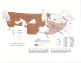
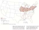
THE 1870 MAP In the quarter-century leading up to 1870, the United States census count for today's Upper Midwest banking region had risen from less than 2,000 to about 800,000 (Figure 13).13 About three-quarters of that growth came from immigration, the remainder from natural increase of the burgeoning resident population. Perhaps two-thirds were foreign, the rest from the eastern United States. Of the foreign immigrants, three-quarters were German, Scandinavian, and Irish. Meanwhile, fewer than 100,000 Indians lived in the region -mainly on the land they had not yet ceded to the advancing whites. The key to white settlement expansion was transportation. Settlers were enlarging the national economy, bringing new resources into the national system, creating new jobs and new wealth. But the new lands had to be tied to the developed Eastern core of the national economy. Improving the speed, capacity, and efficiency of the ties was a constant challenge.
Natural waterways were the first links. Primitive wagon roads connected and extended the water routes. That primitive system was still important on the 1870 map. From St. Paul and Stillwater a fleet of side-wheel and stern-wheel riverboats, with their auxiliary barges, plied the Mississippi to the great St. Louis entrepot. From there the historic system of the Western rivers led to New Orleans, Pittsburgh, and the Missouri River country. From the newly developing Upper Midwest the packets moved fur, grain, hides, and lumber downstream and returned with hardware, machinery, textiles, clothing, groceries, and whiskey, along with 1,000 or 2,000 immigrants each week of the navigation season. Upper tributaries of the Mississippi, from the Wisconsin on the east to Minnesota's Rum River on the west, floated the logs of spring drives from the edges of the northern forest, and the main stem carried football-field-sized rafts of logs and lumber to downstream mills and yards at Winona, Dubuque, Rock Island Davenport, Burlington, and all the way to St. Louis. Completion of the first locks at Sault Ste. Marie in 1855 had extended the Great Lakes waterway northwest into Lake Superior. That provided a direct route to the East from the northern forests and mineral districts of the Canadian Shield—eventual waterway of the famous whaleback ore and grain carriers. Most romantic yet cumbersome of the water arteries was the run from St. Louis to Fort Benton, Montana, or to its makeshift low-water outport 100 miles downstream at Cow Island —the alternate practical heads of navigation on the Missouri. The flat-bottom stern-wheelers were called the mountain boats at St. Louis. Fueled by wood cut on the floodplain or coal and lignite dug from the High Plains valley walls, targets of Indian potshots, the Missouri River packets provided a slender connecting thread across the genuinely wild West. Backbone of the St. Louis fur trade, they moved an estimated million hides and many tons of pure gold down from Fort Benton. They brought hundreds of immigrants as well as supplies of whiskey, guns, ammunition, hardware, drygoods, and groceries to the Montana gold camps, isolated army garrisons, Indian agencies, and trading posts. Boat captains estimated the distance at 3,000 river miles. The journey took seven weeks upstream, two and one-half down. A typical migrant family, traveling from the farm they sold in Missouri to settle in the Gallatin Valley of southwestern Montana, spent 40 days and nights on the boat from St. Joseph to Fort Ben-ton. It is interesting to reflect that today no human habitation on earth is nearly as much as 40 days' travel time from St. Joseph, Missouri. 14
Figure 13. The 1870 Map. The region was beginning to take shape. The Upper Mississippi Valley, the Michigan mining districts, and the Montana gold fields had been settled at densities higher than the two-persons-per-square-mile figure used by the Census Bureau to define the frontier. Half the region had not yet been ceded by the Indians. Sources: notes 15, 16, 17, 18, and 21.
(p. 33)
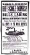
An 1865 handbill gave essential information to shippers and travelers headed from St. Louis across the empty Plains to the Montana gold fields. U.S. National Park Service.
Captain John Mullan's famous military wagon road twisted west from Fort Benton, across the Rockies, to the head of river packet navigation on the Columbia at Fort Walla Walla, Washington Territory. Completed in 1859, it provided a transcontinental river-wagon-river route from St. Louis to Portland and Astoria-for those few with the need, patience, and money.15 By 1870 the expanding railway net was undermining the packet boat business in the East and threatening it in the West. The first through railroad from the Twin Cities to both Chicago and the growing rail corridor across Iowa was already two years old. Two more direct connections to Chicago were imminent. The Milwaukee Road was building its short line between LaCrosse and St. Paul, and the Chicago and Northwestern had reached Eau Claire. Rail connections between Chicago and the Mississippi River had reached Rock Island and Galena in the 1840s, LaCrosse in the 1850s. They had already diverted much of the St. Louis traffic eastward to the Great Lakes and progressively shortened the route from St. Paul to the Atlantic Seaboard. Now, in the 1870s, dependence on the river packets was declining almost completely.
(p. 34) An alternative Eastern link had just opened. Philadelphia's Jay Cooke interests completed the Lake Superior and Mississippi railroad between St. Paul and Duluth in 1869. The embryonic "Zenith City of the Unsalted Seas" was the new land-water transfer point between the Northwest and the nation's economic core. At Carlton, where the line completed its climb from the Duluth waterfront over the St. Louis River gorge to the top of the escarpment and turned south toward St. Paul, Cooke had established a junction and finally begun to build the Northern Pacific. On the 1870 map the line reached 10 miles west on the projected 1,900-mile course to Seattle.16
On the agricultural frontier the St. Paul and Pacific had pushed its main line beyond Willmar and its branch line to St. Cloud. The St. Paul and Sioux City reached into the prairie beyond Mankato. From the river ports of Hastings and Winona, which some boosters viewed as competitive with St. Paul, two lines had pushed westward into the southern Minnesota farming country. Until this time rail building was bringing markedly improved transportation to areas where considerable settlement was already under way, and a network of local roads —albeit dirt-was already in place. Now, in the western Minnesota prairie, that sequence was beginning to reverse. The rails were catching up with the frontier and even getting ahead of it. Westward, county seat business districts, traditionally built around the courthouse square, were giving way to business districts lined up along the tracks and focused on the depot. The epoch of truly rail-led settlement was under way. In addition to the Mullan road, a few other wagon routes still formed part of the arterial network. From the St. Paul and Pacific railhead at St. Cloud, the main stage and wagon road extended northwest to Georgetown, Minnesota, a few miles north of present-day Fargo-Moorhead, where it met the Red River steamer route to Winnipeg. On the other side of the territory, completion of the transcontinental railroad in 1869 had given a new importance to the "Mormon Express" route from Utah and the Oregon Trail to the Montana gold fields. Corinne, Utah, is a few miles east of the famous golden spike location at Promontory. The Bear River enters Great Salt Lake near Corinne, and Union Pacific engineers thought they foresaw an important future for the place as a transfer point to steamboats for Salt Lake City. Hence they selected it also as the railroad's transfer point for Montana. For more than a decade the Corinne route was the fastest to Montana from the East. Regular stages and hundreds of wagons served the gold fields. Celebrated New York and European artists, en route to San Francisco, stopped to perform at the Corinne opera house for travelers, mule skinners, bullwhack-ers, and prospectors. Today the opera house, depot, and most of the business district are gone. Across the tracks from the vacant opera house site, a farm supplies store of a giant Twin Cities-based agricultural cooperative provides a miniscule, less romantic tie with the Upper Midwest.17 These arterial routes appear on our small-scale maps of the region. Much has been written and dramatized about their role in advancing the frontier. But another part of the picture is usually missing. The arterials needed a dense supporting network of secondary roads if there was truly to be settlement of a region. The frontier is most often pictured as an open-air workplace of families clearing, burning, plowing, planting, building shelter for themselves and their animals, dealing with Indians as well as with traders, bankers, and bill collectors. Yet it is at least as useful to think of the frontier as the edge of an expanding dense transportation network. As towns and farms were staked out, in accord with the land survey, the dirt roads advanced simultaneously. So think of the pioneer settlers also as road builders —digging, grading, bridging—coping with the need to get to town, on the one hand, and the need to get to the rural trade area, on the other hand. Emerging System of Cities, Towns, and Trade Areas As the frontier was advancing into the nascent Upper Midwest in 1870, nearly two-thirds of the region's population —about 520,000—lived on farms in the Upper Mississippi Valley. Those were pioneer general farms, producing partly for home consumption and partly for the market. Farmers were experimenting with a great variety of familiar European and American fruit, vegetable, and grain crops to see what would survive and yield in this strange climate. They were husbanding familiar European breeds of cattle, hogs, sheep, and poultry. And they were selling what they could ship to Chicago and the other large, more distant urban markets along the crude rail-river transportation system. The shipments were mainly grain, livestock, cheese, and sour-cream butter. Transportation costs were high, and net returns were low. Produce and fluid milk marketing was limited to nearby towns; and that market was still small, with low returns. In addition, these farmers still had much woodland to clear, countless boulders to move, fences and outbuildings to erect. A big share of the output from farm labor was used on the farm. Commercialization was only beginning. Only one third of the region's population was needed in the towns to carry on commerce.
(p. 35)
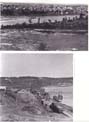
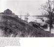
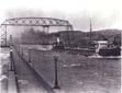
In 1870 Minneapolis (population 13,000), in the upper photo, is viewed from the Winslow House in St. Anthony (population 5,000). The larger town sprawled over the plain between St. Anthony Falls and the rolling glacial moraine country rising two miles to the southwest. The Mississippi floated logs from the northern forest and powered the mills. A few miles downstream at St. Paul (population 20,000), the river broadened into the water transportation artery of the midcontinent. This port (lower photo), seen from Robert Street, was at that time the terminal for river freight mainly from LaCrosse and for rail freight from the cities at St. Anthony Falls and the frontier country just to the west. At the falls and head of navigation, the river nourished the growth of industry and commerce at the gateway between the distant cities of the East and the resources of the emerging Northwest. Upper photo, Minnesota Historical Society (862-B); lower photo, Illingworth, Minnesota Historical Society.
(p. 36)
The most developed farmlands were in the hill country and the glacial moraines of the forest-prairie transition zone, through west-central Wisconsin and northeastern Iowa to central Minnesota, and into the prairie-drift plains across northern Iowa and southwestern Minnesota. America's Spring Wheat Belt was emerging there. The farms were still clustered and scattered, with large areas unclaimed or undeveloped. The fill-in process was quickening near the advancing rail lines, but it remained more gradual in the big spaces between them. On the northern fringe, in Wisconsin, several sizable clusters of farm settlement had developed around Wausau and Chippewa Falls. Those areas were north of the railroads. The soil was stony or sandy. The logging boom was providing winter work in the forest, a chance for additional work in the sawmills, and cutover land practically for the taking. German settlers dominated on that forest frontier, as they had earlier in so many areas across Wisconsin.
Wherever farming began, hamlets and small towns appeared at the same time. By 1870 at least 1,000 of these small non-farm rural settlements existed, with a total population of about 100,000. At least one emerged at a crossroads in virtually every township. The common nucleus was a tavern, an ethnic church, a waterpowered grist mill, a creamery, a general store, and post office or railway stop.18
Thirty-seven larger towns and cities were home to the other 180,000 nonfarm people. The bigger towns distributed goods to the rural hamlets, consolidated the farm product shipments, ran the transportation arteries, and provided professional services as well as department stores and specialty stores for occasional shopping trips.
The largest of these higher-order places was not very large. Of 440,000 people in Minnesota, fewer than 40,000 lived in St. Paul and Minneapolis (including still politically separate St. Anthony). St. Paul and Minneapolis had passed Dubuque as the primary wholesale-retail-service center of the Upper Mississippi Valley. St. Paul, at the practical head of steamboat navigation, with easy road access from the river to the uplands, was the main regional transportation and distribution center. Minneapolis, with the waterpower of St. Anthony Falls and the New England entrepreneurs attracted to it, was the booming industrial center.
One rank below the primary centers were two important cities in the 6,000-9,000 size class. Winona and LaCrosse were ports on the Mississippi. Both were sawmilling centers and grain collection and shipping points. For more than a decade LaCrosse had been the principal transshipping point in the rail-river corridor between Chicago-Milwaukee and St. Paul.
Another rank down the population order, six towns were medium-size shopping and service centers in the 3,000-5,000 class. Four were river towns, including Stillwater on the St. Croix, the region's second largest sawmill-ing center and log and lumber rafting point. Also in this class were Hastings and Red Wing, Minnesota. Tributary valleys allowed relatively easy access to the upland prairies at both of those places, and Red Wing's fireclay resource was exploited by an important pioneer crockery industry. Mankato was in the same size class. The Minnesota River served briefly as a steamboat route in the 1850s and 1860s, and Mankato grew at the big bend, where the waterway made its most southerly penetration of the prairies. Two of the six 3,000-5,000 cities were growing at waterpower sites. Faribault was the county seat in southern Minnesota's Cannon River Line of grain mills, and Chippewa Falls was the largest sawmill and grain mill center on the largest cataract on western Wisconsin's largest tributary of the Mississippi. Twenty towns were in the small shopping and service center class, with 1,000-2,000 population. Six of those were river towns on the Mississippi, and 14 were water-power sites.
Thus, in this emerging agricultural region every nonfarm settlement, from the largest city to the smallest hamlet, was growing at a strategic point in the developing circulation system. Country crossroads were the locations of the large number of small hamlets. Where natural terrain provided a special advantage-a navigable waterway and easy access to it, or the power of a rapid reach of river—the much smaller number of larger towns and cities had emerged. Each of those natural resources saved a critically large amount of capital that would otherwise have been needed to build a town. Furthermore, there was an emerging ordering of the settlements according to their population and their function in the system of production and exchange.
The leading edge of the Upper Mississippi Valley settlements marked the northwestern-most thrust of the contiguous American frontier in 1870. The northern forest section of the frontier stretched across the Upper Midwest from the shore of Green Bay to central Minnesota. The more dynamic western section ran southward from central Minnesota to extreme southeastern South Dakota.
(p. 37)
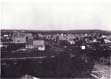
At a waterpower site in southeastern Minnesota's Zumbro River Valley, Rochester was a fast-growing center of pioneer farm trade in 1867, three years after the railroad had reached the city from the Mississippi waterway at Winona. St. Paul Daily News, credit, Benjamin Franklin Upton, Minnesota Historical Society (5752).
Important outliers of settlement had grown along the Great Lakes shores, beyond the contiguous northern frontier. Eastern investors had developed the Copper Range on Michigan's Keweenaw peninsula and the nearby Marquette Iron Range, centered on Ishpeming. The three largest towns on the Copper Range were strung together in a complex of mine derricks, smelters, docks, a few solid business blocks and substantial homes, and shanty districts with a total population of nearly 10,000. Ishpeming had boomed during the preceding decade, along with its neighboring mining town of Negaunee and its two busy ore and timber ports at Marquette and Escana-ba. Meanwhile, at the newborn port of Duluth, in an array of shanties and waterfront storehouses, at the end of the new railroad, on one corner of St. Louis Bay, the 1870 census counted 3,100 inhabitants where only 14 families had lived a year earlier. Ishpeming, the largest of these urban islands in the wilderness, had surged into the 6,000-9,000 population class; five others, including Duluth, were in the 3,000-5,000 group.19 Far to the west, gold had been discovered in Montana in 1862. The first strike came at Bannack, on the mountainous edge of the Beaverhead Valley. Activity spread to notorious Virginia City in 1863 and Last Chance Gulch at Helena in 1864. Subsequent smaller strikes appeared as far east as the Judith Mountains, northeast of Lewistown. Much of the land had not yet been ceded by the Indians, but that hardly mattered. Each discovery brought a new wave of several thousand strangers to the locality. They came mostly from the East and Midwest—many choosing prospecting over soldiering during the Civil War. But also some Europeans and Chinese found their way north from the Union Pacific. Acres of shanties and one or two substantial buildings mushroomed in each camp. Meanwhile a smaller, less publicized group was arriving from every other part of the United States, with, again, a few from Europe. They came to ranch and to farm on the broad benches and along the potential irrigation streams lower in the valleys. They settled in the Missouri headwaters along the Gallatin, Beaverhead, and Sun, and in the Columbia headwaters along the Bitterroot and the upper Clark Fork. They supplied the crowded gold camps, and some assembled considerable wealth in the process. By 1870 the rush had ended. Each boom had subsided quickly and usually left a residue of a few hundred people. They operated the successful mines and worked with the farmers and ranchers at the more rewarding, long-term job of building a stable economy and a few stable towns in these remote but extraordinarily beautiful valleys. Helena, with 4,000 people, had emerged as the territorial capital and largest city. In 1870 about 19,000 people lived in the western Montana country. On the eastern side of the Rocky Mountains, the frontier of that isolated cluster of Americans faced east across 900 miles of Indian lands toward the farming frontier in Minnesota and Iowa.20
(p. 38)
The 1870 census counted 3,100 people living in the raw, booming settlement at the end of the railroad in Duluth. W. H. lllingworth, photo, Minnesota Historical Society (142).
(p. 39)
Beyond the Frontiers
Between the agricultural frontier in Minnesota and the gold frontier in Montana lay one-quarter of a million square miles of land that was nearly empty, by the standards of the white settlers. Most of it was Indian territory. Only four large areas had been ced'ed through treaty by 1870. Two of the ceded areas, Minnesota and eastern Dakota, formed a logical western periphery of the established farming country. The other two, west of the Missouri, were isolated, desultory northerly projections from the vast cessions in Nebraska, Colorado, and Wyoming. Probably numbering about 50,000, the Indians lived in widely scattered, quasi-permanent villages and shifting bands.
The United States government had a very sparse and small presence. The army's Department of Dakota included Minnesota, the Dakota and Montana Territories —a suggestion of the banking region that would come half a century later. Commanded from upstairs headquarters over a downtown St. Paul storefront, the department had about 3,200 troops. They were deployed at Fort Snell-ing—the 50-year-old, original citadel at the head of the Mississippi waterway—and 20 remote outposts. The typical outpost had a stockade protecting a few cabins and huts in an area the size of a city block or smaller, separated from the nearest neighbor by 75 to 300 miles of roadless prairie. Three of the forts — Ripley, Abercrombie, and Ransom — had protected the oxcart routes to the Canadian Red River settlements. By 1870 the main route to Winnipeg bypassed Forts Ripley and Abercrombie, but not Pembina, North Dakota, or the mosquitoes, boulders, and gumbo of the Red River route. Three more forts flew the flag over the eastern Sioux, lands along the Prairie Coteau near the present towns of Sisseton, South Dakota, and Lisbon and Devils Lake, North Dakota. The Missouri steamer route strung together 10 forts and Indian agencies from Fort Buford, near present-day Williston, North Dakota, to the New Ponca Agency, above Yankton, South Dakota. There was no base for 800 river miles or 400 land miles between Fort Buford and Fort Benton. On the Montana side of the Indian country, in addition to the company stationed at Fort Benton, other garrisons in Montana guarded the Sun River settlements and the gold fields to the south, the gold fields and ranches in the Belt Mountains east of Helena, and the Bozeman Pass at the eastern edge of the Gallatin Valley. Connections were tenuous and slow. The eastern forts were supplied by wagon train from St. Paul. The others, though commanded from St. Paul, were supplied from Omaha and St. Louis by river steamers, and by connecting wagon trains beyond Fort Benton. Riverboats churned upstream at 60 miles per day, downstream at 150. Wagon trains might make 30 miles a day, sometimes as little as 10. Except perhaps for the Montana and Red River roads, wagons followed no more than ruts or tracks on the raw land. Surveys were sparse and discontinuous. Maps were crude and often doubtful.
The handful of troops were in the middle of a drama with a complex plot but neither a script nor a director. From one side came the shrill demands of promotional editors, speculators, traders, freighters, hunters, and demagogues, along with the inexorable westward press of settlers. On the other side, they faced the growing restlessness and long-festering social disorganization of the Indians. Tension remained in the aftermath of the Sioux uprisings that flared during the Civil War years. Everyone knew the stories of the bloody incidents between Sioux and white settlers at New Ulm and Spirit Lake, on the southern Minnesota and northern Iowa prairies. Now, more than ever, the tribes were contesting one another and the whites for possession of the buffalo range. The herds furnished food, clothing, and shelter for the Indians. But they also provided income in the barter with white traders for whiskey, guns, powder, and other goods. At the same time, the narrow zone of ceded land separating the farming frontier from the Indian domain was obviously unstable. It had shifted westward all the way from the Mississippi within living memory. Perceptive Indian leaders could sense a relentless squeeze as the farming frontier east of them closed like a vise against the gold and ranching frontier west of them and the solid base of the Union Pacific corridor to the south.21
(p. 40)
Figure 14. National Transportation System, 1869. National systems of commercial agricultural marketing, cities, and towns were in place along the transportation network. The American Manufacturing Belt and Corn Belt had taken their places on the world map and would form the core region of American economic geography for the next century. Source: 1868 Official Railway Guide, modified to include the Union Pacific-Central Pacific line completed the following year.
(p. 41) In contrast, beyond the northern frontier no significant military presence existed in 1870, nor did much tradition of it. The forest wilderness covered 50,000 square miles. Coniferous trees were dominant, especially the fabled white pines. Poorly drained in many places, sandy in some, rough and stony in the rest, short of hot and frost-free weather-the area offered little to reward crop farming. In fact, the advance of the farming frontier was already slowing to a crawl along the line from Green Bay to St. Cloud. But the wilderness held untapped resources for America's burgeoning heavy industries. The rich metallic ores and tall, straight pines were partly known, partly suspected, and almost totally unsurveyed and unmeasured. Big rivers could provide both the power to saw the logs and the waterways to float the product to the prairie markets. Perhaps 20,000 Indians and about 12,000 whites lived in the lands beyond the northern frontier in 1870. Indian domain had been reduced to seven reservations. Nine-tenths of the reservation land was in Minnesota, although about 60 percent of the Indian population was in Wisconsin and Michigan. Indians, whites, and mixed-bloods mingled in the long-standing trading and trapping business. Meanwhile, the invasion by agriculture was slow and spotty, logging was transient, and both had been thus far confined to the southern edge of the wilderness. Decisive armed conflicts over agricultural settlement had occurred much earlier and much farther south.22
Little organized transportation moved through the forest region from either the Great Lakes shores or the agricultural frontier. Mail was carried on foot between a few outposts on Lake Superior, a few towns on the agricultural frontier, and a few trading posts in the forest. An army road temporarily joined Bayfield-mainland port for the Apostle Islands —and the St. Croix Valley. A stage route anticipated the railroad that was soon to close the gap between Escanaba and Menominee-Marinette. And the new ore railroad cut through the narrow isthmus of wilderness between Escanaba and the Marquette Range. Otherwise, it seemed that Americans were largely bypassing the Lake Superior forest country in their westward drive toward the prairie grasslands. But it would not seem that way for long.23 A New Epoch In a larger sense, a new epoch had dawned in the development of the American circulation and settlement system. Upper Midwest development was caught up in the larger drama. A national rail-waterway network was in place from the Atlantic Seaboard into Missouri and Iowa and north of the Ohio and Potomac rivers (Figure 14). In turn, a national commercial agricultural marketing system, and consequently a national system of cities and towns, were all in place along the transportation network. The American Manufacturing Belt and the Corn Belt had taken their positions on the world map. They would make up the core region of American economic geography for the next century.
The nation was ready to exploit and build upon the unique combination of fertile prairies and glacial plains in the Midwest, the gigantic reserves of high-grade coal in the Appalachians, the very large reserves of high-grade iron ore in the Lake Superior district, and the natural Great Lakes waterway to join those rich resource regions. Development had been stimulated by the Civil War. Now new metallurgical technologies were opening an era of cheap steel, changing the United States from a steel importer to a steel exporter. Accompanying revolutionary changes in the capacity and speed of the railroad freight system included heavier rail, heavier locomotives and cars, standard gauge, and improved coupling, blocking, braking. A standardized, integrated network, reaching to all the South and West, would emerge in the decade following 1870. The steel rail epoch of American development had begun.
The development of greatly expanded, more specialized agricultural regions and much larger-scale exploitation of Lake Superior ores and timber were imminent. A Northwest Empire was feasible.24
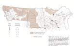
THE 1890 MAP By 1890 the Northwest Empire was on the map (Figure 15). The Upper Midwest banking region was emerging. Within it the population had risen from 700,000 in 1870 to nearly 3 million. Of the 2.2 million increase, immigration accounted for 1.5 million, natural increase for 700,000. Immigrants were equally divided between foreign and United States sources. Sixty percent of the foreign immigrants came from German-language areas of Europe, 20 percent from Scandinavia, the remainder mostly from Ireland, Canada, and Bohemia. More than ever the key to change was transportation. Over the 20-year period, nearly 5 percent of the entire hot-rolled iron and steel production of the United States had been used to lay rail in the hinterland of the Twin Cities.25
(p. 42)
Figure 15. The 1890 Map. The frontier was receding rapidly. Main-line railroads now spanned the entire region, and the branch line network was developing as far west as the Missouri Coteau and north to Lake Superior. Commercial development and urbanization accompanied transportation improvements. The wilderness was beginning to dissolve. Source: note 26.
(p. 43)
One of the last stern-wheelers on the upper Missouri takes on grain from North Dakota's Knife River settlements at the county landing in 1905. Shallow water and sandbars notwithstanding, the river still provided the cheapest way to move freight to the railroad at Bismarck. The storage shed and crude loading chute were minimal improvements; cargo was piled on the dirt bank. Though settled and farmed, this country was still very new. Photo, State Historical Society of North Dakota (C0018).
The Spreading Rail Network
In the part of the region east of the Missouri the railway mileage had grown from about 1,000 to more than 10,000. The railroad map was shaped by three sets of main lines radiating from St. Paul-Minneapolis, Chicago, and Duluth-Superior. The Twin Cities-Chicago corridor now included six lines. Multiple competing lines formed another corridor from the Twin Cities southward to Des Moines, Omaha, and the midcontinent. Yet another bundle of lines swept west and northwest to Aberdeen, Fargo, the Red River Valley, and Winnipeg. The weakest corridor from the Twin Cities narrowed eastward to Green Bay and Upper Michigan.26
Two sets of lines radiating from Chicago and Milwaukee bypassed the Twin Cities on both the eastern and the southern margins of the Upper Midwest. The North Woods lines were extending the accelerating logging campaign into the northern forest all the way to Lake Superior, and they linked Chicago to the ports and mining districts of northern Wisconsin and the Upper Peninsula. The "prairie roads" ran west from Chicago-Milwaukee. They crossed the Iowa and southern Minnesota prairies through LaCrosse, Winona, Man-kato, and Mason City to the James Valley in South Dakota. A third, looser radial web, focused on Duluth-Superior, also bypassed the Twin Cities on the north, west, and east. It linked directly with the Red and James valleys, Chicago-Milwaukee, and the Lake Superior mining districts.
Once the main lines were completed, fill-in by branch lines followed quickly. By 1890 the branch lines had already sprouted thickly from the trunks in northern Iowa and southern Minnesota, and they were beginning to sprout in South Dakota. The distance between trunk lines grew wider with increasing distance from the three major centers, like the widening spaces between spokes of a wheel from the hub toward the rim. The branch lines were essential to fill those voids, especially in the farming areas, more distant from the Twin Cities and Chicago.
(p. 44) In
the northern forest area several local specialized
mining and logging networks were
tied together by the regional trunk lines. Heavily
used tracks connected the mines of five
ranges with their lake ports; the Vermilion, Gogebic, and Menominee ranges had been
opened since 1870 to join the older Copper and Marquette ranges. Meanwhile,
extensive
webs of temporary logging railroads kept shifting
northward with the camps and crews of
loggers. To the west the northern transcontinentals had crossed the Great Plains and the Rockies. The Northern Pacific (NP) began its operation to Pacific tidewater in 1883. A brochure announced that the Pacific Express, "with Pullman and dining cars attached, leaves St. Paul at 8:00 P.M. every day in the week, running through to Portland without change of cars in 4 days." That was a reduction in travel time of about six weeks compared with the wagon and riverboat days. The railroad advertised land along its line, enough for "2,000,000 families, 10,000,000 souls," at $2.60 to $4.00 per acre. James J. Hill had gained control of the St. Paul and Pacific, extended it to the border near Pembina to connect with the Canadian line to Winnipeg, and built west from Grand Forks. In 1890, as his transcontinental line neared completion, his St. Paul, Minneapolis, and Manitoba system had just been renamed the Great Northern (GN).27
The NP and GN had begun to outline a new northern corridor across the western half of the United States. But at the same time other railroads were beginning to delineate the limits of that corridor. The 1890 map showed the first line to serve the Black Hills, and it led eastward to Omaha and Sioux City for connection directly to Chicago and the midcontinent. In southwestern Montana a Union Pacific line had replaced the wagon and stage road to Utah with a direct rail connection from booming Butte to Salt Lake City, Los Angeles, and San Francisco. The Canadian Pacific had completed its line from Port Arthur-Fort William, on Lake Superior, to Vancouver. That would sharply define the northern edge of the GN-NP corridor along the international bound-ary.28
Dramatic changes in water and road transportation accompanied the explosion of railroad building. River packet traffic declined catastrophically. Slow boats on a few tortuous streams could not compete with the trains for passengers, express, mail, or general cargo. The upper Mississippi waterway had become obsolete except for the movement of logs and lumber. The upper Missouri was also going out of use. But it was being abandoned in discontinuous segments. Fort Benton lost part of its hinterland when the Northern Pacific reached western Montana in the early 1880s and was practically finished as a port when the Great Northern reached the area late in the same decade. Riverboat service from Bismarck 150 miles upstream to lignite diggings and Fort Berthold continued until after the turn of the century when the service was finally displaced by the last railway branch line construction and the beginnings of automobile transportation. Stern-wheelers had plied between Sioux City, Yankton, and Fort Pierre, connecting there with wagons and stages to the Black Hills, until rails reached Chamberlain and Pierre from Chicago in 1880.29
Great Lakes packet ships had the same competitive problem. But while the packet business declined, the fleet of specialized bulk carriers grew rapidly. Between 1870 and 1890 annual shipments through the Sault Ste. Marie canal rose from one-half million to 9 million tons. Iron ore accounted for half of the total, westbound coal and eastbound grain for most of the remainder. The quantum increase in Lake Superior grain shipments reflected the growth of long-haul movement by rail to Duluth-Superior. Never before had grain moved overland so far in such large quantity so cheaply. Coal was now moving in great quantity from the Appalachians through Lake Erie ports and the Lakehead for the boilers, blacksmith forges, and stoves of the Upper Midwest.
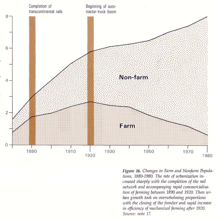
While these massive changes took place in the arterial transportation network, the supporting system of local roads was changing just as dramatically. More than 100,000 miles of rural dirt roads were added to the grid in the newly settled Minnesota and Dakota prairies, and several thousand more in the new settlements in Montana. More important, there was a great increase in the effectiveness of the dirt road secondary network because of the insertion of thousands of miles of railroad arterials. What had been a very primitive single-mode land transportation system, of wagon roads only, had become a much more sophisticated system of feeders and arterials. The dirt road in front of a farmhouse or country store looked the same as it always had, but it now led to a railroad only a few miles away. With 10 times the average daily speed and 50 times the capacity of a wagon, the train was a link to distant cities, ports, and markets. Cities, Towns, and Hinterlands With increasing intensity of transportation and exchange came a faster rate of urbanization. The region's nonfarm population rose 300 percent, or about 1.0 million, in 20 years, while the farm population rose only 150 percent, or about 1.2 million. Natural increase on the farms was nearly double that in the towns and cities. Thus the surplus farm population was already rising and spilling into the urban places. Of the 1.5 million net migration into the region between 1870 and 1890, half went to newly settled farms, and half filled new urban jobs and households created by the increase in transportation and trade. Total population of the hamlets, towns, and cities now numbered more than 1.2 million (Figure 16). (p. 45)
One of the last generation of whaleback freighters steams into Lake Superior from St. Louis Bay, Duluth-Superior, in 1920, past the predecessors of today's aerial lift bridge and breakwater. One of the fleet of famous Great Lakes passenger liners is visible below the smoke plume, and a bit of central Duluth's impresssive, turn-of-the-century facade of dockside warehouses projects above the freighter's bow. McKenzie, Duluth, MN, photo, Minnesota Historical Society.
Only 76 places in the entire region were classed as urban, with populations of 2,000 or more. But they accounted for nearly three-fourths of the nonfarm population and an equal share of the nonfarm growth. Among these larger places, there was a widening spread in size between the largest and the smallest, and an increasing variety in the functions they performed. The 1870 map showed four size classes; the 1890 map, six.
(p. 46)
Figure 16. Changes in Farm and Nonfarm Populations, 1880-1980. The rate of urbanization increased sharply with the completion of the rail network and accompanying rapid commercialization of farming between 1890 and 1920. Then urban growth took on overwhelming proportions with the closing of the frontier and rapid increase in efficiency of mechanized farming after 1920. Source: note 17. The Twin Cities had surged into a class by themselves, not only in the region but in the entire northern transcontinental corridor. The combined population had reached 300,000. Even Portland, Seattle, and Tacoma each numbered less than 50,000. The city growing around the falls had reached 165,000 in the 1890 census; the city growing around the steamboat landing, 133,000. In the fall of that year, the two were raging at each other through press and public meetings over alleged frauds in the new head count. Each was concerned, from a different point of view, about the widening population gap since Minneapolis had pulled ahead of St. Paul in 1880. But such conflicts were hardly more than a diversion from the basic activity of the place. Immigrants arrived on the trains from Chicago at the rate of a few hundred to a few thousand per week. Many remained in the cities. More went through to the open farmlands in western Minnesota and beyond. From Pullman palace cars on the same trains came financiers, sales agents, and the families of St. Paul and Minneapolis elite returning from Eastern business and shopping trips. Railroading was entering its greatest boom period. Sawmilling was at its peak. Since 1885 Minneapolis had been the largest flour-milling center and primary wheat market in the country. Minneapolis-controlled lines of country elevators followed the rails to the Rockies and into Canada. Together with the big hardware and grocery wholesalers, chain bankers, and new brokerage firms, they were lacing together the region. Below the Twin Cities level were two centers in the 25,000-38,000 size class. La-Crosse was a major center downstream on the Mississippi. Its growth had slowed. River traffic was moribund, and the agricultural hinterland was limited by the growth of new, competing centers farther west. In contrast, Duluth had been booming. A surge of Eastern capital had been pumped into the building of warehouses, grain elevators, sawmills, foundries, and business blocks. The notion was that something like another Chicago would grow at this new transcontinental transshipment point in the heart of the continent. The grain traffic was indeed materializing. The building boom, itself, provided strong support to the sawmills. Hardware wholesalers were managing to compete with Twin Cities firms in the western hinterlands. However, the weakening position of general cargo packet ships against rail competition through the Twin Cities was raising some doubt about the analogy to Chicago. So was the opening of the Canadian transcontinental railroad and a competing port at the Canadian Lakehead beside Thunder Bay. But that would be offset within two years by the opening of the fabulous Mesabi Iron Range.
(p. 47) Two
cities in the same size class as Duluth lay
just south of the region. Dubuque, like La-Crosse,
had passed its heyday as a port on the upper
Mississippi. But, across Iowa, Sioux City
was booming. As a busy node in the prairie railroad lines from Chicago, it was
competing with Omaha in
the newly developed markets of
the James Valley and the Black Hills. Two cities in the region were in the 13,000-18,000 size class. One, Eau Claire, had become the principal industrial and railroad center at the rapids of the Chippewa in Wisconsin. The other, Helena, with the state capital and a legacy of smelting and wholesale merchandising for the gold fields, was still the largest city in Montana. Sixteen large shopping and service centers were in the 8,000-12,000 population range. Their locations reflected the advantages of a natural resource concentration, or an early start, or both. Eight were iron-mining centers and Great Lakes ports shipping either ore or timber and receiving coal. Four more were at waterpower sites-Wausau, Chippewa Falls, St. Cloud, and Sioux Falls. St. Cloud had an additional early advantage as the railhead and staging point on the Twin Cities-Winnipeg route. Sioux Falls, though laid out as a waterpower industrial town by Dubuque promoters in the 1850s, had the problem of unreliable flow of the Sioux River in the subhumid prairie climate. Then it had drawn only branch railroads and was growing in the shadow of Sioux City. Stillwater and Winona were continuing as thriving centers of sawmilling and timber transportation on the rivers. Winona had an added role as grain miller and shipper for the prairies to the west. And Mankato, from its early start in the days of Minnesota River steamboating, had consolidated its commercial position where the main Twin Cities-Sioux City rail line intersected one of the main Chicago-James Valley lines.
Fifty-four cities were medium and small shopping and service centers, in the 2,000-7,000 population range. They had not yet reached the size of the 22 select, larger cities; and most of them never would. But all had grown enough to stand out from the vast seedbed of hamlets and small towns scattered along the region's transportation arteries. Nearly all of these urban places were county seats, and that initial boost meant the presence of the land records, sheriff, jail, judges, and accompanying cadre of professional people and local press. But that was not always enough because most of the region's county seats were too small to be urban places.
Seven distinctly different factors, working singly or in many different combinations, had caused these 54 cities to move out from the crowd. 1. Cities prospered at the intersection of rail lines of two different regional grids: Twin Cities and Chicago or Twin Cities and Duluth. For commercial travelers and distributors, towns at those intersections had the advantage of direct access to different competing major wholesale centers. A few important examples from the large roster of places with that kind of location include Albert Lea, Mankato, Willmar, and Austin, Minnesota; Mason City and Sheldon, Iowa; and most of the centers in the James Valley. 2.
A waterpower
site provided an initial advantage,
even if its practical value was giving
way to steam or electricity by the 1890s. Examples
include Cloquet and Fergus Falls, Minnesota;
Rhinelander, Menomonie, and River Falls,
Wisconsin; and the Cedar Valley towns in Iowa. 3. Selection of
locations for state institutions
boosted local basic employment and a resident
professional community. Examples are the capitals at Pierre and Bismarck; the
colleges at Vermillion, Brookings,
and Rapid City, South Dakota, at Grand
Forks and Fargo, North Dakota, and at River Falls and
Menomonie, Wisconsin.
4. Important mineral deposits meant the powerful advantage of discovery and,
of course, the hopeless disadvantage of
depletion. But discovery stimulated
the growth of many urban places.
Examples in 1890 were already
extremely varied. For instance, some of the
Copper Range towns were declining while Butte's
Anaconda mines and Lead's Homestake
were booming. 5.
Ports such as
Manistique, Michigan, and
Washburn, Wisconsin, served the booming
logging industry in the northern forest 6.
Development thrived in centers of large,
tightly knit religious and ethnic communities
such as the Norwegian concentration 7. Also significant in some communities' growth was the experienced selection of a townsite with amenities of woods, water, and hills, and an initial thrust of capital and entrepreneurship, exemplified by Alexandria, Minnesota, and Watertown, South Dakota. Of all the factors, this one was perhaps the most important in the long run and the least tangible.
(p. 48)
Settlers hauling buffalo bones to the railroad siding through downtown Minot, North Dakota, 1883. Photo, State Historical Society of North Dakota (C1777).
(p. 49) The same locational advantages, with different degrees of intensity and different chance combinations, accounted for the emergence of every urban center in the region. With urbanization under way> differential city growth and concentration of growth at larger cities were also under way. Boom, slowdown, decline, and instability had become part of the scene. Causes and effects of these variations in growth were already becoming complex, evolving, idiosyncratic. Each class of places, whether based on size or function, already contained many cities that were only temporarily in that class. Some cities were passing through a particular class on the way up, others on the way down — each for its own reasons. Meanwhile, the classes, themselves, were changing as the system was growing and changing. Many people were developing stakes in the security and future of these young cities. They included not only influential entrepreneurs and professionals but also small-home owners, clerks, and technicians. In even two short decades the complex causes and fickle results of growth had begun to unfold. The process was fascinating and frustrating to the boosters, leaders, and many others —not only in Minneapolis and St. Paul but also in the whole array of smaller urban centers.
The vast areas of northern forest wilderness and western Indian lands on the 1870 map were virtually dissolved 20 years later. The United States census defined the frontier as the line of two persons per square mile, average county density. In the northern forest zone, only far northeastern Minnesota still lay beyond that line in 1890. Elsewhere feverish logging and mining expansion had carried the frontier as far north as it could go in the United States. Even in the Minnesota Arrowhead Region a gold rush had come and gone, and iron mining had begun on the Vermilion Range.30
In the West railroad construction had led the prairie farming frontier out to the Souris and Missouri, though it had slowed down on the higher parts of the coteau east of Minot and Bismarck. Disagreement persisted among the Sioux over the status of the Black Hills. Nevertheless, white settlement already dominated the area. The separate frontiers of the western Montana valleys had merged and expanded. On the 1890 map, corridors of settlement bulged north past Great Falls to the Marias, east to the Judith Basin, the Musselshell, and far down the Yellowstone. A long corridor of white settlement followed the Great Northern High Line up the Missouri and the Milk between Williston and Havre. The Indians were mostly subdued. Farms and ranches were beginning to operate around the Little Big Horn battlefield, the Bear Paws, and Slim Buttes, where soldiers, warriors, and Indian women and children had been killed in massacres in the 1870s. Within the vast areas of Indian land on the 1870 map, the tribes had mostly clustered around government agencies near the Turtle Mountains, Devils Lake, along the Missouri, north of the Big Horns, and on the Pine Ridge east of the Black Hills. On the Pine Ridge the last of the massacres occurred in 1890 at Wounded Knee. The division of lands was still not settled, but today's reservations were beginning to take shape.31 Meanwhile, on the same 1870 Indian lands, the buffalo were nearly extinct by 1890. In recent memory, herds of thousands had delayed riverboats on the Fort Benton runs and awed the adventurers on wagon trains from St. Paul to the gold fields. The herds had been slaughtered for robes and sport. But there was no practically accessible market for most of the meat. Virtually all of the carcasses had been left to rot and the bones to bleach. In the 1880s agents along the new transcontinental railroads had a market for the bones. Rendering plants back East reduced them to carbon black and fertilizer. The same industry had taken the bones from the central Great Plains during the construction of the Union Pacific and the Santa Fe, and it was turning to the north. The agents would buy the bones for cash or take them in trade for supplies. In response, settlers, Indians, and mixed-bloods alike fanned out on the prairie to gather the remains by the wagonload and haul them to the sidetracks. Millions of tons were shipped out on the Northern Pacific and Great Northern, mainly to St. Louis and down the Great Lakes to Detroit. By the early 1890s the supply was depleted. The cleanup of the northern Great Plains was finished.32
|