|
- 28 -
|
|
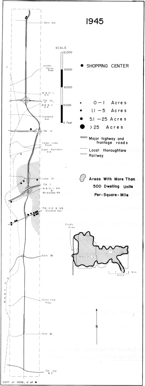
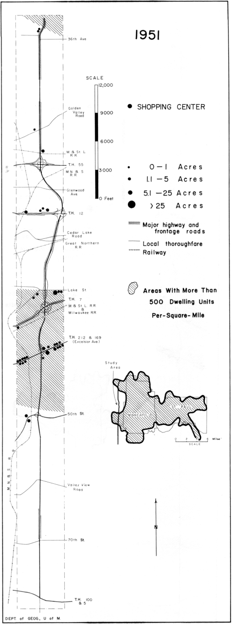
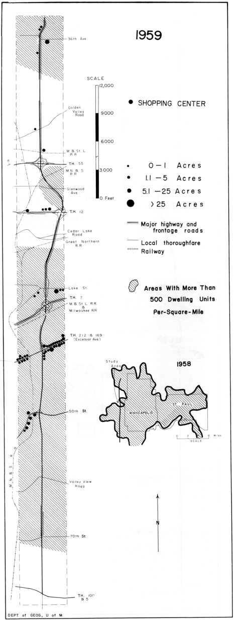
The data suggest that the growth of acreage devoted to shopping center-type uses has been directly proportional to the growth of dwelling unit density. It is also apparent, however, that there is no simple or direct relationship between residential growth and the highway pattern. While spokes of metropolitan residential development have followed some routes, they have ignored others. This is a result of the fact that residential growth directions have been determined by a number of forces, of which the modern highway pattern is only one.
Other factors include the attitude of developers toward flat land, streetcar and early road
patterns, and municipal sewer and water systems. |
|
 |
Describing the traffic density pattern. |
|
|
| Table 2 -- Acreage of Shopping Center Uses Per Square Mile, in the Study Strip, in Segments of Different Dwelling-Unit Densities. |
|
|
Acres of Shopping Center Uses Per Square Mile |
Dispersed
Residential
Density |
Low
Residential
Density |
Medium
Residential
Density |
High
Residential
Density |
|
| 0.0 |
0.0 |
0.4 |
0.1* |
| 0.0 |
0.1 |
0.5 |
2.0* |
| 0.1 |
0.1 |
|
2.3 |
|
|
|
3.5 |
|
|
|
|
|
0.45 |
1.98 |
|
|
*Segments located in Robbinsdale. |
|
|
|
3. Highway-Oriented Business Uses and Traffic Volume
Establishments in the highway-oriented class are the only group which showed a tendency to locate near heavy traffic. To describe |
|
|
|
|
- 29 -
|
|
the traffic density pattern, the study strip was divided into seven parts. Each part contained one major intersection of the Belt Line and a radial highway. All of the major radials belong to the state or
federal systems; all carry heavy burdens of both commuter and intercity traffic. The seven parts of the study strip and the traffic volumes are indicated in Table 3. A total was obtained for the average daily number of vehicles entering or leaving each intersection on both the
|
|
|
| Table 3 -- Traffic Volume and Acreage of Major Land Uses, Segments of the Belt Line Adjoining 7 Major Highway Intersections. |
|
| Major Intersecting Highway |
Average Daily Vehicle Flow
Through the Intersection (000's) |
Individual Intersection Traffic
Count as Per Cent of Total for 7 Intersections |
Highway Oriented Use Acreage as
Per Cent of Strip Total |
Manufacturing Use Acreage as Per
Cent of Strip Total |
Manufacturing Use Acreage as Per
Cent of Strip Total |
Wholesaling Use Acreage as Per
Cent of Strip Total |
|
| T.H. 12 |
151 |
24 |
19 |
12 |
17 |
79 |
T.H. 169
(Excelsior Ave.) |
100 |
19 |
25 |
45 |
6 |
1 |
| T.H. 55 |
96 |
15 |
12 |
1 |
34 |
2 |
T.H. 7
(Lake Street) |
96 |
15 |
11 |
20 |
28 |
15 |
T.H. 212
(50th Street) |
80 |
13 |
17 |
12 |
4 |
3 |
| T.H. 152 |
71 |
11 |
6 |
19 |
0 |
1 |
78th St.
(T.H. 5-100) |
40 |
7 |
10 |
0 |
13 |
3 |
|
|
|
- 30 -
|
|
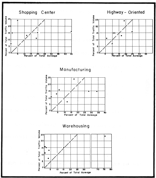
Belt Line and the major radial highway. The total at each major intersection was then taken as an index of the density of traffic within each of the seven segments of the study strip. This traffic density index was then compared with the acreage of land in each of the four major use classes. The results of the comparison are indicated in Table 3 and the graph in Figure 18. More than the other three classes, the highway-oriented retail and service uses appear to be located in response to the presence of a large volume of traffic. |
|
|
|
|
Figure 18.
|
|
|
|
|
- 31 -
|
|
4. Concentration of Retail and Service Establishments Near Major Highway Intersections |
|
|
|
|
Retail and service establishments generally have located in the vicinity of major highway intersections. This applies to neighborhood-oriented shopping center establishments as well as to highway-oriented establishments. |
|
|
Location of retail and service establishments. |
|
|
|
All highway-oriented and shopping center-type establishments were classified according to their distance from one of eight major intersections. Those intersections included the seven listed in Table 3 and, also, the intersection of the Belt Line with T.H. 278 in Robbinsdale, at the north end of the study strip. The results are indicated in Table 4. |
|
|
Classifying establishments. |
|
|
|
Table 4 indicates that 91 per cent of all retail and service establishments located on the Belt Line are less than 2, 500 feet from a major highway intersection. This is almost twice the percentage which could be expected if these uses were distributed evenly along the study strip. Long stretches of the highway have stood without commercial development for long periods of time; yet they are served by frontage roads, and they have been free of competing, noncommercial land uses. The land remote from major intersections was ignored by commercial establishments. This distribution pattern can be explained only by the attraction of major intersections where the number of directions of rapid access is maximized. It is also |
|
|
Explaining the distribution pattern of retail and service uses. |
|
|
|
- 32 -
|
|
noteworthy that the modal distance from the major intersections was the same for every year of observation. In other words, there was a tendency for a loose commercial-use pattern to develop initially then gradually increase in density, rather than a tendency for development to begin immediately adjacent to the intersection and expand outward.
|
|
|
|
| Table 4 -- Retail and Service Establishments (Shopping Center and Highway-Oriented) in Relation to Available Highway Frontage. |
|
|
Distance From Major Intersection (feet) |
Per Cent of Total Frontage |
Per Cent of Total Retail & Service
Establishments |
|
|
0-500 |
10 |
37 |
|
500-1000 |
10 |
19 |
| Belt Line |
1000-1500 |
10 |
13 |
| (33 establishments) |
1500-2000 |
10 |
10 |
|
2000-2500 |
10 |
12 |
|
2500 |
50 |
9 |
|
|
|
|
|
0-500 |
18 |
16 |
|
500-1000 |
18 |
13 |
| Major Radials |
1000-1500 |
18 |
15 |
| (120 establishments) |
1500-2000 |
18 |
33 |
|
2000-2500 |
18 |
12 |
|
2500 |
10 |
11 |
|
|
|
Table 4 also indicates that four-fifths of the establishments in these intersection areas front the radial highways rather than the Belt Line. This is related to the timing of Belt Line construction and also to zoning policy. |
|
|
Why radial highways have more firms than the Belt Line. |
|
|
|
- 33 -
|