|
BELT LINE
COMMERCIAL-INDUSTRIAL DEVELOPMENT
A Case Study in the Minneapolis-St. Paul Metropolitan Area |
|
|
|
|
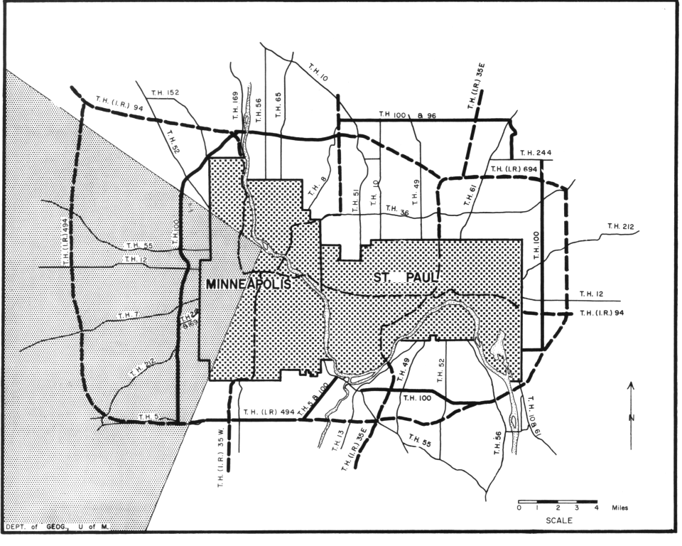
T.H. 100 circumscribes
the Twin Cities and also serves as a distributor route to major
intersecting radial highways on the periphery of the Twin Cities
metropolitan area (Figure 1). The portion of T.H. 100 lying west of
Minneapolis is the most heavily used. The segment is approximately
12 miles long, extending north-south through a series of suburban
communities from Robbinsdale to the northern boundary of
Bloomington. It is the subject of one major part of this study
(Figure 1). |
|
 |
Location of T.H. 100. |
|
|
|
Most of the western
segment of the Belt Line was opened as a four-lane highway between
1936 and 1938. Only the section between 50th Street and Excelsior
Avenue was opened earlier. A four-lane concrete pavement was
constructed there in 1928. Since the original construction surfacing
has been improved, the north- and south-bound lanes have been
divided, additional grade separations and traffic interchanges have
been constructed, and both access and crossing points have been
limited. |
|
|
Opening of the Belt Line. |
|
|
|
Along the parts of the
route opened in the 1930's an unusually wide right-of-way was
acquired and an exceptionally large amount of landscaping was done.
Both of these accomplishments were results of the fortuitous
combination of two factors. One factor was the imaginative,
resourceful, and dedicated effort of Mr. Carl Graeser, the |
|
|
Beautification of the Belt Line route. |
|
|
|
- 9 -
|
|
Figure 1.
The present and projected Belt Line highways around the
Minneapolis-St. Paul metropolitan area. Heavy solid lines mark the
position of T.H. 100. Heavy dashed lines mark the Interstate Highway
routes. The "western quadrant", to which this study refers, is
indicated by fine stippling.
|
|
- 10 -
|
|
project engineer, and the encouragement of his chief, Mr. O. L. Kipp, who was then construction engineer in the Minnesota Highway Department. The other factor was the availability of WPA labor to implement a national policy for outdoor beautification. |
|
|
|
|
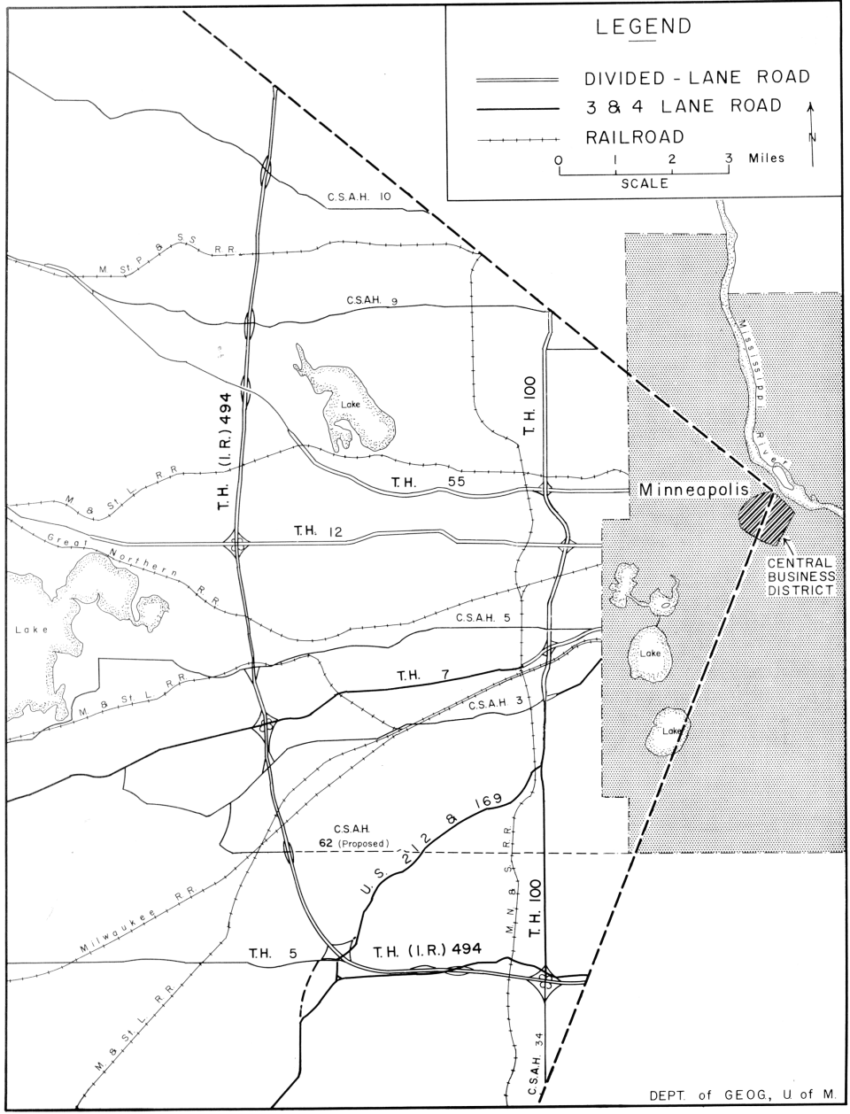
Plans are now well advanced for a new "super" Belt Line. It will be part of T.H. (I.R.) 494 in the Federal Interstate Freeway system. The route of T.H. (I.R.) 494 will lie west of the present Belt Line (Figure 2). It is expected to be opened in 1965. The new T.H. (I.R.) 494 is planned to be a divided highway with restricted access and no grade crossings. No frontage roads are contemplated in existing |
|
|
The "super" Belt Line is part of the Federal Interstate Freeway system. |
|
|
|
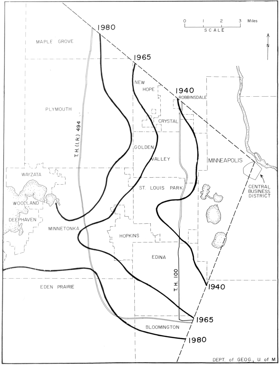
The position of T.H. (I.R.) 494 in the changing geographic patterns of the metropolitan area in 1965 will be analogous in many ways to the position of the west segment of T.H. 100 in 1940. Both are arcs within the same western quadrant of metropolitan Minneapolis (Figure 2). Both are crossed by the same major highways and railways radiating from the central city. Both will have been constructed in the fringe of urban expansion (Figure 3). Each will have had the highest design standards used in Minnesota at the time of its construction. Therefore, developments of various land uses along T.H. 100 since its completion may fore shadow future developments along T. H. (I.R.) 494. They may also shed further light upon Belt Line developments in general. |
|
|
Similarities between the Belt Line and the "super" Belt Line. |
|
|
|
- 11 -
|
|
This report includes an analysis of the location of commercial and industrial land development along the west segment of T.H. 100, an attempt to project the amount and location of demand for land for similar developments on proposed T.H. (I.R.) 494, and a discussion on the findings of the study as they pertain to highway planning. |
|
|
Projection and planning - the purposes of this study. |
|
|
|
1. The Old Belt Line -- T.H. 100
This first portion of the study concerns the demand for land for different uses, the types of locations in which major classes of non-residential use have developed, and types of structure and parcel size which have characterized different uses and different locations along the Belt Line. Finally, there is an attempt to estimate the amount of remaining land which is likely to be developed for commercial or industrial purposes and the consequence of reaching the ceiling of available land for development. The study strip is roughly one mile wide; it embraces, and is generally centered on, the highway.
|
|
|
Scope and objectives. |
|
|
|
The Development of Commercial and Industrial Land
Four hundred and thirty-one acres of land were developed for commercial or industrial purposes in the study strip during the 14 years 1945-1959. This is approximately 5.6 per cent of a total of 7680 acres in the study strip. This is a substantial part of the increase which occurred during that period in the Twin Cities metropolitan area as a whole--perhaps 10 per cent, or more, of the land used for new
manu-
|
|
|
Commercial - industrial development centered in the study. |
|
|
|
- 12 -
|
|
Figure 2.
The old Belt Line (T.H. 100), proposed new Belt Line (T. H. (I. R.) 494), and major radial highways and railways in the western quadrant of the Twin Cities metropolitan area.
|
|
- 13 -
|
|
Figure 3.
The similar positions of the old and new Belt Lines with reference to the advancing urban frontier. Heavy solid lines indicate generalized western boundaries of 500 or more dwelling units per square mile at successive times.
|
|
- 14 -
|
|
facturing and warehousing development and perhaps 10 to 15 per cent of the land used for new retail and service establishments.1
Yet the study strip includes only about two per cent of the urbanized or partly urbanized land of the metropolitan area. |
|
|
|
|
For purposes of this study, developed or used land is defined as those ownership parcels which have been improved by the erection of structures. Acreage figures refer to the parcels on which the structures stand.2
Four major use classes have been recognized. |
|
|
Use classes defined. |
|
|
|
1. Manufacturing--Dominant function is primary production or fabrication. May also include office or warehouse space on premises. Category includes one technical training school with shops, storage space, and office.
2. Warehousing--Storage and wholesale distribution are dominant functions. May also include office space on the premises. |
|
|
|
|
Plans are now well advanced for a new "super" Belt Line. It will be part of T.H. (I.R.) 494 in the Federal Interstate Freeway system. The route of T.H. (I.R.) 494 will lie west of the present Belt Line (Figure 2). It is expected to be opened in 1965. The new T.H. (I.R.) 494 is planned to be a divided highway with restricted access and no grade crossings. No frontage roads are contemplated in existing |
|
|
|
|
1
Percentages based upon a comparison with growth rates indicated in Metropolitan Land Study, Twin Cities Metropolitan Planning Commission, 1960, pp. 42-43. Percentages are merely indicative for data in the two studies are not strictly comparable. |
|
|
|
|
2 In this study strip there are relatively few cases in which the parcel area is significantly larger than the used or landscaped area. |
|
|
|
|
- 15 -
|
|
3. Shopping
Center-Type Retail and Service Uses--Stores and service establishments of types needed to serve a residential neighborhood and traditionally included in neighborhood shopping centers.3
4. Highway-Oriented Retail and Service
Uses--Service and retail establishments which are dependent upon a large volume of traffic or a high degree of metropolitan accessibility but are amenable to locations away from the central business
district.4 |
|
|
|
|
The latter two categories are subdivisions of the broad retail and service group. The general meanings of these four major categories of land use are self-evident. Specific definitions are listed in Appendix 1. As of 1959 a total of 228 establishments are included in the four classes. |
|
|
Two hundred twenty-eight businesses included in the four use categories. |
|
|
|
Observations from a current field survey and plat maps, together with earlier aerial photographic surveys, were used to determine the acreage and location of establishments at six different times--1940, |
|
|
Observations from survey and plat maps and aerial surveys. |
|
|
|
3 These subclasses of the general retail and service group are borrowed from a
study by Brian Berry, "Ribbon Developments in the Urban Business Pattern",
Annals of the Association of American Geographers, 49:2 (June, 1959), pp. 145-155. |
|
|
|
|
|
- 16 -
|
|
1945, 1951, 1953, 1957, and 1959. Acreage of each used parcel was taken from detailed plat maps, scale one inch to 200 feet, for 1959. The time period in which the present use was established was determined from the sequence of aerial photographs. The use was determined by field observation for 1959 and interpreted from aerial photographs for earlier years. Table 1 shows the acreage of the four major uses in 1940 and the area of increment during each of the subsequent time intervals.5
The maps in Figures 4-14 illustrate the evolution of the geographic pattern. |
|
|
|
|
Table 1 -- Additions to Commercial and Industrial Acreage in the Old Belt Line Strip.
| Year First Mapped |
Shopping Center Uses (Acres) |
Highway Oriented Uses (Acres) |
Manufacturing Uses (Acres) |
Warehousing Uses (Acres) |
Total |
Cumulative Total |
| 1940 |
3.8 |
15.3 |
40.1* |
7.9** |
67.1 |
61.7 |
| 1945 |
2.1 |
13.0 |
0.0 |
0.1 |
15.2 |
82.3 |
| 1951 |
15.1 |
32.1 |
49.5 |
7.7 |
107.4 |
189.7 |
| 1953 |
4.0 |
28.2 |
27.7 |
1.0 |
60.9 |
250.6 |
| 1957 |
4.1 |
20.6 |
78.4 |
42.4 |
145.5 |
396.1 |
| 1959 |
8.1 |
16.7 |
23.3 |
54.4 |
102.5 |
498.6 |
| Total |
40.2 |
125.9 |
219.0 |
113.5 |
498.6 |
|
|
*A quarrying-washing-block manufacturing enterprise. Most
of the land was occupied by quarry and storage yards.
**Two large terminal grain elevators. |
|
|
|
5 No land has shifted from commercial and industrial to other uses although this may occur in the future. |
|
|
|
|
- 17 -
|
Previous Page Next
Page
|